
Wiesenbach-Forellenhof (Taubertal)
A cycling route starting in Wiesenbach, Baden-Wurttemberg, Germany.
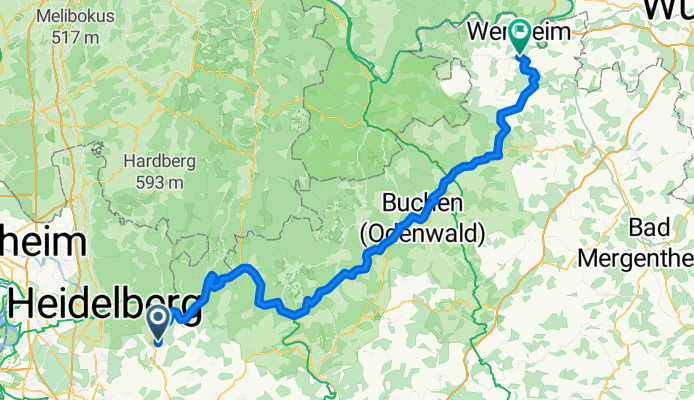
Overview
About this route
Netter kleiner Campingplatz mit einfachen Sanitäreneinrichtungen. Sehr gutes Essen.Gaststätte Telefon: (09342) 7133. Treckingrad ist ausreichend. Wenig Verkehr.
- -:--
- Duration
- 104.5 km
- Distance
- 738 m
- Ascent
- 708 m
- Descent
- ---
- Avg. speed
- ---
- Max. altitude
Route quality
Waytypes & surfaces along the route
Waytypes
Track
41.8 km
(40 %)
Quiet road
18.8 km
(18 %)
Surfaces
Paved
67.9 km
(65 %)
Unpaved
20.9 km
(20 %)
Asphalt
61.7 km
(59 %)
Gravel
20.9 km
(20 %)
Continue with Bikemap
Use, edit, or download this cycling route
You would like to ride Wiesenbach-Forellenhof (Taubertal) or customize it for your own trip? Here is what you can do with this Bikemap route:
Free features
- Save this route as favorite or in collections
- Copy & plan your own version of this route
- Split it into stages to create a multi-day tour
- Sync your route with Garmin or Wahoo
Premium features
Free trial for 3 days, or one-time payment. More about Bikemap Premium.
- Navigate this route on iOS & Android
- Export a GPX / KML file of this route
- Create your custom printout (try it for free)
- Download this route for offline navigation
Discover more Premium features.
Get Bikemap PremiumFrom our community
Other popular routes starting in Wiesenbach
 Mückenloch - Neckarhäuserhof - Neckarsteinach - Ngd - Wiesenbach
- Distance
- 24.3 km
- Ascent
- 368 m
- Descent
- 370 m
- Location
- Wiesenbach, Baden-Wurttemberg, Germany
 WDH - Drachenhöhlenweg
- Distance
- 15.8 km
- Ascent
- 339 m
- Descent
- 339 m
- Location
- Wiesenbach, Baden-Wurttemberg, Germany
 Rund um Sinheim über die Höhen
- Distance
- 36.1 km
- Ascent
- 443 m
- Descent
- 448 m
- Location
- Wiesenbach, Baden-Wurttemberg, Germany
 Feierabendrunde
- Distance
- 21.5 km
- Ascent
- 256 m
- Descent
- 256 m
- Location
- Wiesenbach, Baden-Wurttemberg, Germany
 Neckargemünd - Angelbachtal
- Distance
- 51.6 km
- Ascent
- 155 m
- Descent
- 153 m
- Location
- Wiesenbach, Baden-Wurttemberg, Germany
 Odenwaldtour
- Distance
- 101.9 km
- Ascent
- 1,969 m
- Descent
- 1,885 m
- Location
- Wiesenbach, Baden-Wurttemberg, Germany
 Weissenstein Heiligenberg
- Distance
- 48.5 km
- Ascent
- 667 m
- Descent
- 667 m
- Location
- Wiesenbach, Baden-Wurttemberg, Germany
 Steinerner Tisch - Neckargemünd
- Distance
- 35.4 km
- Ascent
- 421 m
- Descent
- 418 m
- Location
- Wiesenbach, Baden-Wurttemberg, Germany
Open it in the app