

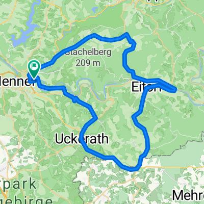
2025-01 Hennef bis Düren
A cycling route starting in Hennef, North Rhine-Westphalia, Germany.
Overview
About this route
- 4 h 35 min
- Duration
- 80.6 km
- Distance
- 232 m
- Ascent
- 170 m
- Descent
- 17.6 km/h
- Avg. speed
- 148 m
- Max. altitude

Route quality
Waytypes & surfaces along the route
Waytypes
Path
41.1 km
(51 %)
Track
14.9 km
(18 %)
Surfaces
Paved
65.2 km
(81 %)
Unpaved
0.9 km
(1 %)
Asphalt
47.8 km
(59 %)
Paved (undefined)
16.7 km
(21 %)
Continue with Bikemap
Use, edit, or download this cycling route
You would like to ride 2025-01 Hennef bis Düren or customize it for your own trip? Here is what you can do with this Bikemap route:
Free features
- Save this route as favorite or in collections
- Copy & plan your own version of this route
- Split it into stages to create a multi-day tour
- Sync your route with Garmin or Wahoo
Premium features
Free trial for 3 days, or one-time payment. More about Bikemap Premium.
- Navigate this route on iOS & Android
- Export a GPX / KML file of this route
- Create your custom printout (try it for free)
- Download this route for offline navigation
Discover more Premium features.
Get Bikemap PremiumFrom our community
Other popular routes starting in Hennef
 Rechts und Links der Sieg
- Distance
- 48.8 km
- Ascent
- 552 m
- Descent
- 454 m
- Location
- Hennef, North Rhine-Westphalia, Germany
 Pfannkuchenmühlen-Route
- Distance
- 47.2 km
- Ascent
- 485 m
- Descent
- 494 m
- Location
- Hennef, North Rhine-Westphalia, Germany
 wahnbachtlsperre
- Distance
- 5.7 km
- Ascent
- 147 m
- Descent
- 149 m
- Location
- Hennef, North Rhine-Westphalia, Germany
 CITO CTF 2013 Erweiterung
- Distance
- 24.4 km
- Ascent
- 407 m
- Descent
- 386 m
- Location
- Hennef, North Rhine-Westphalia, Germany
 2025-01 Hennef bis Düren
- Distance
- 80.6 km
- Ascent
- 232 m
- Descent
- 170 m
- Location
- Hennef, North Rhine-Westphalia, Germany
 Erlebnissweg Talsperrenweg
- Distance
- 23.6 km
- Ascent
- 455 m
- Descent
- 455 m
- Location
- Hennef, North Rhine-Westphalia, Germany
 Wahnbachtalsperre
- Distance
- 57.7 km
- Ascent
- 215 m
- Descent
- 218 m
- Location
- Hennef, North Rhine-Westphalia, Germany
 Siegtal - Linz am Rhein
- Distance
- 45.6 km
- Ascent
- 122 m
- Descent
- 130 m
- Location
- Hennef, North Rhine-Westphalia, Germany
Open it in the app