

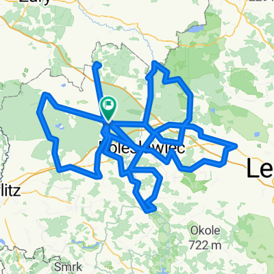
Okolice Bolesławca
A cycling route starting in Bolesławiec, Lower Silesian Voivodeship, Poland.
Overview
About this route
Real distance: 401 km
- 22 h 42 min
- Duration
- 389.9 km
- Distance
- 1,808 m
- Ascent
- 1,808 m
- Descent
- 17.2 km/h
- Avg. speed
- 270 m
- Max. altitude

Route quality
Waytypes & surfaces along the route
Waytypes
Road
167.7 km
(43 %)
Quiet road
70.2 km
(18 %)
Surfaces
Paved
257.3 km
(66 %)
Unpaved
19.5 km
(5 %)
Asphalt
230 km
(59 %)
Paved (undefined)
27.3 km
(7 %)
Continue with Bikemap
Use, edit, or download this cycling route
You would like to ride Okolice Bolesławca or customize it for your own trip? Here is what you can do with this Bikemap route:
Free features
- Save this route as favorite or in collections
- Copy & plan your own version of this route
- Split it into stages to create a multi-day tour
- Sync your route with Garmin or Wahoo
Premium features
Free trial for 3 days, or one-time payment. More about Bikemap Premium.
- Navigate this route on iOS & Android
- Export a GPX / KML file of this route
- Create your custom printout (try it for free)
- Download this route for offline navigation
Discover more Premium features.
Get Bikemap PremiumFrom our community
Other popular routes starting in Bolesławiec
 Dolina Bobru
- Distance
- 82.7 km
- Ascent
- 705 m
- Descent
- 554 m
- Location
- Bolesławiec, Lower Silesian Voivodeship, Poland
 Kruszyn - Zgorzelec
- Distance
- 70.8 km
- Ascent
- 343 m
- Descent
- 333 m
- Location
- Bolesławiec, Lower Silesian Voivodeship, Poland
 Antywyprawka 5 2018
- Distance
- 164.2 km
- Ascent
- 726 m
- Descent
- 727 m
- Location
- Bolesławiec, Lower Silesian Voivodeship, Poland
 Rynek 41, Bolesławiec do Kliczków 8, Osiecznica
- Distance
- 19.5 km
- Ascent
- 100 m
- Descent
- 129 m
- Location
- Bolesławiec, Lower Silesian Voivodeship, Poland
 Boleslawiec Kliczkow petla polnocna niebieski
- Distance
- 31.3 km
- Ascent
- 125 m
- Descent
- 121 m
- Location
- Bolesławiec, Lower Silesian Voivodeship, Poland
 Okolice Bolesławca
- Distance
- 389.9 km
- Ascent
- 1,808 m
- Descent
- 1,808 m
- Location
- Bolesławiec, Lower Silesian Voivodeship, Poland
 Bolesławiec - Suszki petla poludniowa
- Distance
- 31.6 km
- Ascent
- 214 m
- Descent
- 221 m
- Location
- Bolesławiec, Lower Silesian Voivodeship, Poland
 Bolesławiec - Legnica
- Distance
- 61.2 km
- Ascent
- 116 m
- Descent
- 188 m
- Location
- Bolesławiec, Lower Silesian Voivodeship, Poland
Open it in the app