
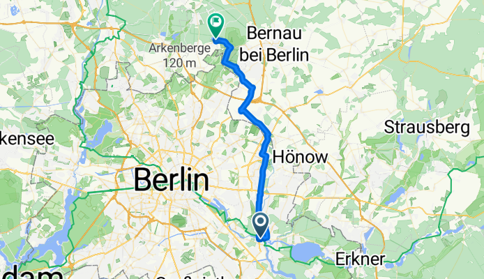
Overview
About this route
- 2 h 14 min
- Duration
- 36.5 km
- Distance
- 122 m
- Ascent
- 97 m
- Descent
- 16.3 km/h
- Avg. speed
- 82 m
- Max. altitude
Part of
Berlin -Usedom gefahren
13 stages
Route quality
Waytypes & surfaces along the route
Waytypes
Path
16.8 km
(46 %)
Quiet road
9.5 km
(26 %)
Surfaces
Paved
26.6 km
(73 %)
Asphalt
23.7 km
(65 %)
Concrete
2.9 km
(8 %)
Undefined
9.9 km
(27 %)
Continue with Bikemap
Use, edit, or download this cycling route
You would like to ride 1 I Panketal or customize it for your own trip? Here is what you can do with this Bikemap route:
Free features
- Save this route as favorite or in collections
- Copy & plan your own version of this route
- Sync your route with Garmin or Wahoo
Premium features
Free trial for 3 days, or one-time payment. More about Bikemap Premium.
- Navigate this route on iOS & Android
- Export a GPX / KML file of this route
- Create your custom printout (try it for free)
- Download this route for offline navigation
Discover more Premium features.
Get Bikemap PremiumFrom our community
Other popular routes starting in Köpenick
 Ausflug in die Märkische Schweiz
- Distance
- 124.4 km
- Ascent
- 285 m
- Descent
- 288 m
- Location
- Köpenick, State of Berlin, Germany
 Köpenick-Erkner-Hohenbinde-Schmöckwitz-Köpenick
- Distance
- 48 km
- Ascent
- 95 m
- Descent
- 97 m
- Location
- Köpenick, State of Berlin, Germany
 Hirtestr. (Berlin) nach Bahnhofstraße 61A, Berlin
- Distance
- 26.6 km
- Ascent
- 242 m
- Descent
- 311 m
- Location
- Köpenick, State of Berlin, Germany
 Hausrunde Ost
- Distance
- 68.7 km
- Ascent
- 100 m
- Descent
- 101 m
- Location
- Köpenick, State of Berlin, Germany
 Müggelsee und Erkner
- Distance
- 45.3 km
- Ascent
- 134 m
- Descent
- 131 m
- Location
- Köpenick, State of Berlin, Germany
 Müggelseeumrundung
- Distance
- 30.4 km
- Ascent
- 1,114 m
- Descent
- 1,112 m
- Location
- Köpenick, State of Berlin, Germany
 2021 Spreewald Tag 3: Version 1 Köpenick - Müggelsee - Neue Mühle, 40 km
- Distance
- 39.9 km
- Ascent
- 140 m
- Descent
- 140 m
- Location
- Köpenick, State of Berlin, Germany
 Tempelhof
- Distance
- 54.8 km
- Ascent
- 101 m
- Descent
- 112 m
- Location
- Köpenick, State of Berlin, Germany
Open it in the app