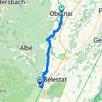
France Day 2 the long way
A cycling route starting in Saint-Hippolyte, Alsace-Champagne-Ardenne-Lorraine, France.
Overview
About this route
- 2 h 35 min
- Duration
- 45.6 km
- Distance
- 51 m
- Ascent
- 97 m
- Descent
- 17.6 km/h
- Avg. speed
- 240 m
- Avg. speed
Route quality
Waytypes & surfaces along the route
Waytypes
Track
19.5 km
(43 %)
Quiet road
12 km
(26 %)
Surfaces
Paved
24.9 km
(55 %)
Unpaved
5.9 km
(13 %)
Asphalt
15.7 km
(34 %)
Paved (undefined)
9.2 km
(20 %)
Continue with Bikemap
Use, edit, or download this cycling route
You would like to ride France Day 2 the long way or customize it for your own trip? Here is what you can do with this Bikemap route:
Free features
- Save this route as favorite or in collections
- Copy & plan your own version of this route
- Sync your route with Garmin or Wahoo
Premium features
Free trial for 3 days, or one-time payment. More about Bikemap Premium.
- Navigate this route on iOS & Android
- Export a GPX / KML file of this route
- Create your custom printout (try it for free)
- Download this route for offline navigation
Discover more Premium features.
Get Bikemap PremiumFrom our community
Other popular routes starting in Saint-Hippolyte
- Von Saint-Hippolyte bis Mülhausen
- Distance
- 88.1 km
- Ascent
- 365 m
- Descent
- 366 m
- Location
- Saint-Hippolyte, Alsace-Champagne-Ardenne-Lorraine, France
- France Day 2 the long way
- Distance
- 45.6 km
- Ascent
- 51 m
- Descent
- 97 m
- Location
- Saint-Hippolyte, Alsace-Champagne-Ardenne-Lorraine, France
- saint hipollyte - haute königsburg
- Distance
- 7 km
- Ascent
- 562 m
- Descent
- 122 m
- Location
- Saint-Hippolyte, Alsace-Champagne-Ardenne-Lorraine, France
- BFA D04 Kintzheim - Selestat - Illkirch
- Distance
- 66.8 km
- Ascent
- 29 m
- Descent
- 584 m
- Location
- Saint-Hippolyte, Alsace-Champagne-Ardenne-Lorraine, France
- Etappe-2 - Vogesen
- Distance
- 77.7 km
- Ascent
- 1,233 m
- Descent
- 1,175 m
- Location
- Saint-Hippolyte, Alsace-Champagne-Ardenne-Lorraine, France
- Route des Vins II
- Distance
- 30.8 km
- Ascent
- 214 m
- Descent
- 652 m
- Location
- Saint-Hippolyte, Alsace-Champagne-Ardenne-Lorraine, France
- 20220830 Colmar
- Distance
- 39.8 km
- Ascent
- 339 m
- Descent
- 394 m
- Location
- Saint-Hippolyte, Alsace-Champagne-Ardenne-Lorraine, France
- Alsace 2008: Champ du Feu
- Distance
- 105 km
- Ascent
- 1,163 m
- Descent
- 1,160 m
- Location
- Saint-Hippolyte, Alsace-Champagne-Ardenne-Lorraine, France
Open it in the app