

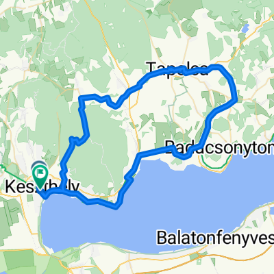
Lake Balaton
A cycling route starting in Keszthely, Zala County, Hungary.
Overview
About this route
Bicycle trip around Lake Balaton, Hungary
- 4 h 5 min
- Duration
- 71 km
- Distance
- 358 m
- Ascent
- 341 m
- Descent
- 17.4 km/h
- Avg. speed
- 173 m
- Max. altitude
Route quality
Waytypes & surfaces along the route
Waytypes
Cycleway
39.6 km
(56 %)
Quiet road
19.4 km
(27 %)
Surfaces
Paved
63.3 km
(89 %)
Unpaved
0.7 km
(1 %)
Asphalt
63.3 km
(89 %)
Unpaved (undefined)
0.3 km
(<1 %)
Continue with Bikemap
Use, edit, or download this cycling route
You would like to ride Lake Balaton or customize it for your own trip? Here is what you can do with this Bikemap route:
Free features
- Save this route as favorite or in collections
- Copy & plan your own version of this route
- Sync your route with Garmin or Wahoo
Premium features
Free trial for 3 days, or one-time payment. More about Bikemap Premium.
- Navigate this route on iOS & Android
- Export a GPX / KML file of this route
- Create your custom printout (try it for free)
- Download this route for offline navigation
Discover more Premium features.
Get Bikemap PremiumFrom our community
Other popular routes starting in Keszthely
 Keszthely-Szigliget-Tapolca-Keszthely
- Distance
- 72.2 km
- Ascent
- 437 m
- Descent
- 443 m
- Location
- Keszthely, Zala County, Hungary
 Lake Balaton
- Distance
- 71 km
- Ascent
- 358 m
- Descent
- 341 m
- Location
- Keszthely, Zala County, Hungary
 Belga csoport ötödik nap
- Distance
- 54.7 km
- Ascent
- 145 m
- Descent
- 146 m
- Location
- Keszthely, Zala County, Hungary
 keszthely
- Distance
- 38.3 km
- Ascent
- 122 m
- Descent
- 134 m
- Location
- Keszthely, Zala County, Hungary
 Pipacs utca 55, Keszthely - Pipacs utca 57, Keszthely
- Distance
- 13.7 km
- Ascent
- 58 m
- Descent
- 48 m
- Location
- Keszthely, Zala County, Hungary
 KH - Rezi - Óhíd - Zalaszentgrót - Sarmelék - KH
- Distance
- 81.2 km
- Ascent
- 382 m
- Descent
- 385 m
- Location
- Keszthely, Zala County, Hungary
 KIS-BALATON kör
- Distance
- 77.9 km
- Ascent
- 370 m
- Descent
- 368 m
- Location
- Keszthely, Zala County, Hungary
 A piros+ panorámája
- Distance
- 26.9 km
- Ascent
- 385 m
- Descent
- 392 m
- Location
- Keszthely, Zala County, Hungary
Open it in the app