

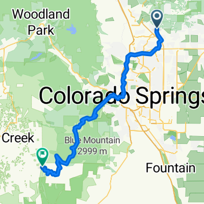
Route to Goose Gossage Skatepark
A cycling route starting in Black Forest, Colorado, United States.
Overview
About this route
- 52 min
- Duration
- 14.7 km
- Distance
- 13 m
- Ascent
- 219 m
- Descent
- 17.1 km/h
- Avg. speed
- 2,080 m
- Max. altitude

Route quality
Waytypes & surfaces along the route
Waytypes
Cycleway
11.7 km
(80 %)
Path
2.1 km
(14 %)
Surfaces
Paved
14.1 km
(96 %)
Unpaved
0.6 km
(4 %)
Concrete
13 km
(89 %)
Asphalt
0.7 km
(5 %)
Continue with Bikemap
Use, edit, or download this cycling route
You would like to ride Route to Goose Gossage Skatepark or customize it for your own trip? Here is what you can do with this Bikemap route:
Free features
- Save this route as favorite or in collections
- Copy & plan your own version of this route
- Sync your route with Garmin or Wahoo
Premium features
Free trial for 3 days, or one-time payment. More about Bikemap Premium.
- Navigate this route on iOS & Android
- Export a GPX / KML file of this route
- Create your custom printout (try it for free)
- Download this route for offline navigation
Discover more Premium features.
Get Bikemap PremiumFrom our community
Other popular routes starting in Black Forest
 Route to Goose Gossage Skatepark
- Distance
- 14.7 km
- Ascent
- 13 m
- Descent
- 219 m
- Location
- Black Forest, Colorado, United States
 Reata Road 16720, Peyton to Reata Court 16525, Peyton
- Distance
- 41.7 km
- Ascent
- 309 m
- Descent
- 283 m
- Location
- Black Forest, Colorado, United States
 Crestone Peak Trail 7715, Colorado Springs to Montarbor Drive 7145, Colorado Springs
- Distance
- 6.6 km
- Ascent
- 39 m
- Descent
- 149 m
- Location
- Black Forest, Colorado, United States
 Falcon N 20 Mi
- Distance
- 32.3 km
- Ascent
- 264 m
- Descent
- 264 m
- Location
- Black Forest, Colorado, United States
 Skaway
- Distance
- 75.3 km
- Ascent
- 2,597 m
- Descent
- 2,045 m
- Location
- Black Forest, Colorado, United States
 Cherry Plum to Pulpit Rock
- Distance
- 29.4 km
- Ascent
- 354 m
- Descent
- 331 m
- Location
- Black Forest, Colorado, United States
 Cherry Plum to Pulpit Rock
- Distance
- 12.5 km
- Ascent
- 120 m
- Descent
- 240 m
- Location
- Black Forest, Colorado, United States
 Peyton Post Office to Querida Drive 1002, Colorado Springs
- Distance
- 40.4 km
- Ascent
- 65 m
- Descent
- 139 m
- Location
- Black Forest, Colorado, United States
Open it in the app