

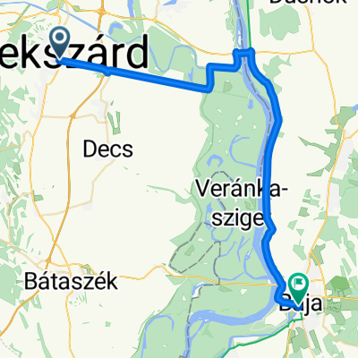
From Szekszárd to Baja
A cycling route starting in Szekszárd, Tolna County, Hungary.
Overview
About this route
- 2 h 21 min
- Duration
- 41.3 km
- Distance
- 85 m
- Ascent
- 91 m
- Descent
- 17.6 km/h
- Avg. speed
- 101 m
- Max. altitude

Route quality
Waytypes & surfaces along the route
Waytypes
Access road
20.2 km
(49 %)
Cycleway
14.1 km
(34 %)
Surfaces
Paved
39.7 km
(96 %)
Asphalt
36.8 km
(89 %)
Concrete
2.9 km
(7 %)
Undefined
1.7 km
(4 %)
Continue with Bikemap
Use, edit, or download this cycling route
You would like to ride From Szekszárd to Baja or customize it for your own trip? Here is what you can do with this Bikemap route:
Free features
- Save this route as favorite or in collections
- Copy & plan your own version of this route
- Sync your route with Garmin or Wahoo
Premium features
Free trial for 3 days, or one-time payment. More about Bikemap Premium.
- Navigate this route on iOS & Android
- Export a GPX / KML file of this route
- Create your custom printout (try it for free)
- Download this route for offline navigation
Discover more Premium features.
Get Bikemap PremiumFrom our community
Other popular routes starting in Szekszárd
 Szekszárd sötétvölgy október
- Distance
- 15.2 km
- Ascent
- 361 m
- Descent
- 361 m
- Location
- Szekszárd, Tolna County, Hungary
 Bartina 15
- Distance
- 15.7 km
- Ascent
- 451 m
- Descent
- 429 m
- Location
- Szekszárd, Tolna County, Hungary
 0. nap
- Distance
- 13.1 km
- Ascent
- 158 m
- Descent
- 105 m
- Location
- Szekszárd, Tolna County, Hungary
 A két híd turája
- Distance
- 74.4 km
- Ascent
- 74 m
- Descent
- 73 m
- Location
- Szekszárd, Tolna County, Hungary
 Gemenci-erdő körbetekerése, avagy a Két híd túrája
- Distance
- 80.9 km
- Ascent
- 91 m
- Descent
- 91 m
- Location
- Szekszárd, Tolna County, Hungary
 "8"-as túra
- Distance
- 34.9 km
- Ascent
- 368 m
- Descent
- 368 m
- Location
- Szekszárd, Tolna County, Hungary
 From Szekszárd to Baja
- Distance
- 41.3 km
- Ascent
- 85 m
- Descent
- 91 m
- Location
- Szekszárd, Tolna County, Hungary
 Szekszárd-Sárpilis-Szálka-Szekszárd
- Distance
- 49.9 km
- Ascent
- 216 m
- Descent
- 216 m
- Location
- Szekszárd, Tolna County, Hungary
Open it in the app