

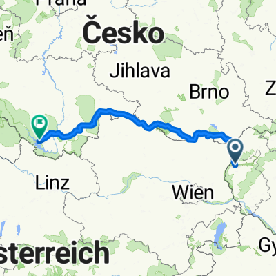
Malacky- Pernek- Kuchyňa -Modr. Dolina- Čermák
A cycling route starting in Malacky, Bratislavský kraj, Slovak Republic.
Overview
About this route
Asfalt - cesty, polne / lesne cesty
- 1 h 50 min
- Duration
- 25.5 km
- Distance
- 483 m
- Ascent
- 54 m
- Descent
- 13.8 km/h
- Avg. speed
- 595 m
- Avg. speed

Continue with Bikemap
Use, edit, or download this cycling route
You would like to ride Malacky- Pernek- Kuchyňa -Modr. Dolina- Čermák or customize it for your own trip? Here is what you can do with this Bikemap route:
Free features
- Save this route as favorite or in collections
- Copy & plan your own version of this route
- Sync your route with Garmin or Wahoo
Premium features
Free trial for 3 days, or one-time payment. More about Bikemap Premium.
- Navigate this route on iOS & Android
- Export a GPX / KML file of this route
- Create your custom printout (try it for free)
- Download this route for offline navigation
Discover more Premium features.
Get Bikemap PremiumFrom our community
Other popular routes starting in Malacky
 Malacky - Jakubov - Suchohrad
- Distance
- 15.4 km
- Ascent
- 28 m
- Descent
- 47 m
- Location
- Malacky, Bratislavský kraj, Slovak Republic
 Kuchyňa - Buková - Pezinská Baba - Kuchyňa
- Distance
- 92.5 km
- Ascent
- 640 m
- Descent
- 639 m
- Location
- Malacky, Bratislavský kraj, Slovak Republic
 Malacky- Pernek- Kuchyňa -Modr. Dolina- Čermák
- Distance
- 25.5 km
- Ascent
- 483 m
- Descent
- 54 m
- Location
- Malacky, Bratislavský kraj, Slovak Republic
 Záhorácka do Záhorácka
- Distance
- 12.2 km
- Ascent
- 51 m
- Descent
- 103 m
- Location
- Malacky, Bratislavský kraj, Slovak Republic
 Malacky - Kostolište - Jakubov
- Distance
- 10.5 km
- Ascent
- 9 m
- Descent
- 22 m
- Location
- Malacky, Bratislavský kraj, Slovak Republic
 Šumava 2008:V.Leváre-Černá v Pošumaví
- Distance
- 322.5 km
- Ascent
- 2,383 m
- Descent
- 1,973 m
- Location
- Malacky, Bratislavský kraj, Slovak Republic
 Duklianskych hrdinov 16 do Duk. hrdinov 6A
- Distance
- 30.5 km
- Ascent
- 104 m
- Descent
- 101 m
- Location
- Malacky, Bratislavský kraj, Slovak Republic
 Malacky - rybníky Rakáreň
- Distance
- 11 km
- Ascent
- 92 m
- Descent
- 45 m
- Location
- Malacky, Bratislavský kraj, Slovak Republic
Open it in the app