

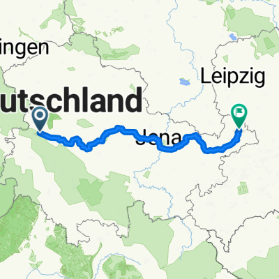
Thüringer Radfernwege - 11 - Thüringer Städtekette - D-Route 4
A cycling route starting in Eisenach, Thuringia, Germany.
Overview
About this route
The Thuringian Cities Chain is a cycling route of about 225 km through culturally and scenically appealing Thuringia, along the Thuringian cities. It runs from the gates of the Thuringian Forest at Eisenach in the west all the way across the entire state to the skat city of Altenburg in the east. The Thuringian Cities Chain is particularly suitable for culture enthusiasts and touring cyclists.
- -:--
- Duration
- 233.6 km
- Distance
- 1,500 m
- Ascent
- 1,543 m
- Descent
- ---
- Avg. speed
- 369 m
- Max. altitude
Continue with Bikemap
Use, edit, or download this cycling route
You would like to ride Thüringer Radfernwege - 11 - Thüringer Städtekette - D-Route 4 or customize it for your own trip? Here is what you can do with this Bikemap route:
Free features
- Save this route as favorite or in collections
- Copy & plan your own version of this route
- Split it into stages to create a multi-day tour
- Sync your route with Garmin or Wahoo
Premium features
Free trial for 3 days, or one-time payment. More about Bikemap Premium.
- Navigate this route on iOS & Android
- Export a GPX / KML file of this route
- Create your custom printout (try it for free)
- Download this route for offline navigation
Discover more Premium features.
Get Bikemap PremiumFrom our community
Other popular routes starting in Eisenach
 kurze Tour
- Distance
- 17.3 km
- Ascent
- 213 m
- Descent
- 205 m
- Location
- Eisenach, Thuringia, Germany
 große Runde
- Distance
- 62.1 km
- Ascent
- 474 m
- Descent
- 474 m
- Location
- Eisenach, Thuringia, Germany
 Thüringer Radfernwege - 11 - Thüringer Städtekette - D-Route 4
- Distance
- 233.6 km
- Ascent
- 1,500 m
- Descent
- 1,543 m
- Location
- Eisenach, Thuringia, Germany
 Eisenach -Kerspenhausen
- Distance
- 79.7 km
- Ascent
- 537 m
- Descent
- 549 m
- Location
- Eisenach, Thuringia, Germany
 Eisenach-Creuzburg
- Distance
- 43.3 km
- Ascent
- 283 m
- Descent
- 275 m
- Location
- Eisenach, Thuringia, Germany
 Eisenach und 4 Flüsse
- Distance
- 276.4 km
- Ascent
- 381 m
- Descent
- 380 m
- Location
- Eisenach, Thuringia, Germany
 12.07.24 Eisenach-Wilhelmglücksbrunn
- Distance
- 34.3 km
- Ascent
- 245 m
- Descent
- 245 m
- Location
- Eisenach, Thuringia, Germany
 Eisenach-Gotha
- Distance
- 43.2 km
- Ascent
- 272 m
- Descent
- 190 m
- Location
- Eisenach, Thuringia, Germany
Open it in the app