

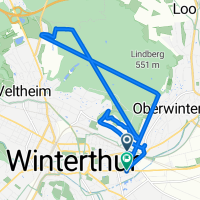
Route zu Burghof
A cycling route starting in Mattenbach (Kreis 7) / Deutweg, Canton of Zurich, Switzerland.
Overview
About this route
- 1 h 18 min
- Duration
- 22.6 km
- Distance
- 129 m
- Ascent
- 188 m
- Descent
- 17.4 km/h
- Avg. speed
- 484 m
- Max. altitude
Route quality
Waytypes & surfaces along the route
Waytypes
Quiet road
6.4 km
(28 %)
Cycleway
5.6 km
(25 %)
Surfaces
Paved
19.5 km
(86 %)
Unpaved
1.8 km
(8 %)
Asphalt
19.4 km
(86 %)
Gravel
1.3 km
(6 %)
Continue with Bikemap
Use, edit, or download this cycling route
You would like to ride Route zu Burghof or customize it for your own trip? Here is what you can do with this Bikemap route:
Free features
- Save this route as favorite or in collections
- Copy & plan your own version of this route
- Sync your route with Garmin or Wahoo
Premium features
Free trial for 3 days, or one-time payment. More about Bikemap Premium.
- Navigate this route on iOS & Android
- Export a GPX / KML file of this route
- Create your custom printout (try it for free)
- Download this route for offline navigation
Discover more Premium features.
Get Bikemap PremiumFrom our community
Other popular routes starting in Mattenbach (Kreis 7) / Deutweg
 Winterthur -> Appenzell
- Distance
- 93.8 km
- Ascent
- 1,406 m
- Descent
- 1,071 m
- Location
- Mattenbach (Kreis 7) / Deutweg, Canton of Zurich, Switzerland
 bike tour from Winterthur to Wetzikon (ZH)
- Distance
- 24.2 km
- Ascent
- 256 m
- Descent
- 155 m
- Location
- Mattenbach (Kreis 7) / Deutweg, Canton of Zurich, Switzerland
 Unterer Deutweg, Winterthur to Seuzacherstrasse, Dinhard
- Distance
- 15.4 km
- Ascent
- 190 m
- Descent
- 187 m
- Location
- Mattenbach (Kreis 7) / Deutweg, Canton of Zurich, Switzerland
 Rund ums Tösstal
- Distance
- 96.2 km
- Ascent
- 1,468 m
- Descent
- 1,468 m
- Location
- Mattenbach (Kreis 7) / Deutweg, Canton of Zurich, Switzerland
 winterthur
- Distance
- 20.7 km
- Ascent
- 313 m
- Descent
- 312 m
- Location
- Mattenbach (Kreis 7) / Deutweg, Canton of Zurich, Switzerland
 Route zu Burghof
- Distance
- 22.6 km
- Ascent
- 129 m
- Descent
- 188 m
- Location
- Mattenbach (Kreis 7) / Deutweg, Canton of Zurich, Switzerland
 Forrenberg Wald Rund
- Distance
- 9.4 km
- Ascent
- 162 m
- Descent
- 162 m
- Location
- Mattenbach (Kreis 7) / Deutweg, Canton of Zurich, Switzerland
 Abendroute Loker 160709
- Distance
- 26.1 km
- Ascent
- 110 m
- Descent
- 110 m
- Location
- Mattenbach (Kreis 7) / Deutweg, Canton of Zurich, Switzerland
Open it in the app