
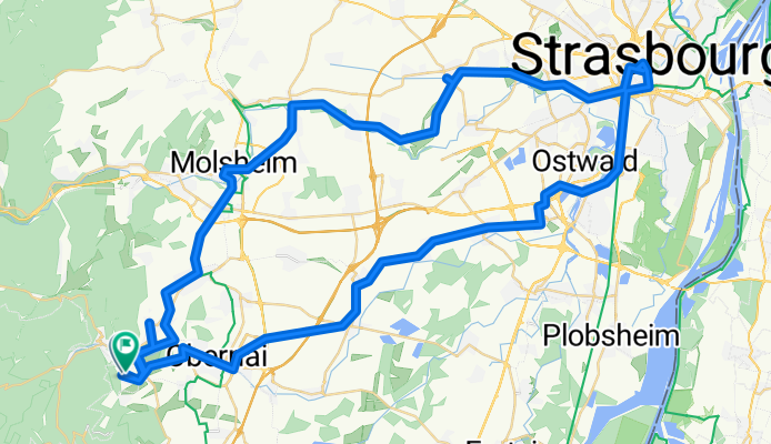
Ottrott-Strasbourg-Ottrott
A cycling route starting in Ottrott, Grand Est, France.
Overview
About this route
- 5 h 40 min
- Duration
- 89.9 km
- Distance
- 435 m
- Ascent
- 454 m
- Descent
- 15.9 km/h
- Avg. speed
- 314 m
- Max. altitude
Route quality
Waytypes & surfaces along the route
Waytypes
Cycleway
39.1 km
(44 %)
Quiet road
16.6 km
(18 %)
Surfaces
Paved
71.5 km
(79 %)
Unpaved
1 km
(1 %)
Asphalt
66.7 km
(74 %)
Paved (undefined)
4.6 km
(5 %)
Continue with Bikemap
Use, edit, or download this cycling route
You would like to ride Ottrott-Strasbourg-Ottrott or customize it for your own trip? Here is what you can do with this Bikemap route:
Free features
- Save this route as favorite or in collections
- Copy & plan your own version of this route
- Split it into stages to create a multi-day tour
- Sync your route with Garmin or Wahoo
Premium features
Free trial for 3 days, or one-time payment. More about Bikemap Premium.
- Navigate this route on iOS & Android
- Export a GPX / KML file of this route
- Create your custom printout (try it for free)
- Download this route for offline navigation
Discover more Premium features.
Get Bikemap PremiumFrom our community
Other popular routes starting in Ottrott
 Molsheim - Mont Sainte-Odile
- Distance
- 203.9 km
- Ascent
- 3,107 m
- Descent
- 3,675 m
- Location
- Ottrott, Grand Est, France
 Ottrott-Strasbourg-Ottrott
- Distance
- 89.9 km
- Ascent
- 435 m
- Descent
- 454 m
- Location
- Ottrott, Grand Est, France
 Klingenthal(95km)
- Distance
- 105.6 km
- Ascent
- 2,957 m
- Descent
- 2,868 m
- Location
- Ottrott, Grand Est, France
 ottrott 5 sept 10
- Distance
- 50 km
- Ascent
- 1,357 m
- Descent
- 1,348 m
- Location
- Ottrott, Grand Est, France
 4. Etappe TransVogesentour
- Distance
- 66 km
- Ascent
- 2,286 m
- Descent
- 2,097 m
- Location
- Ottrott, Grand Est, France
 BTR 2017
- Distance
- 1,099.4 km
- Ascent
- 5,445 m
- Descent
- 5,562 m
- Location
- Ottrott, Grand Est, France
 1st training
- Distance
- 47.1 km
- Ascent
- 1,211 m
- Descent
- 1,197 m
- Location
- Ottrott, Grand Est, France
 70km Klingenthal-Donon
- Distance
- 124.2 km
- Ascent
- 3,038 m
- Descent
- 3,071 m
- Location
- Ottrott, Grand Est, France
Open it in the app