
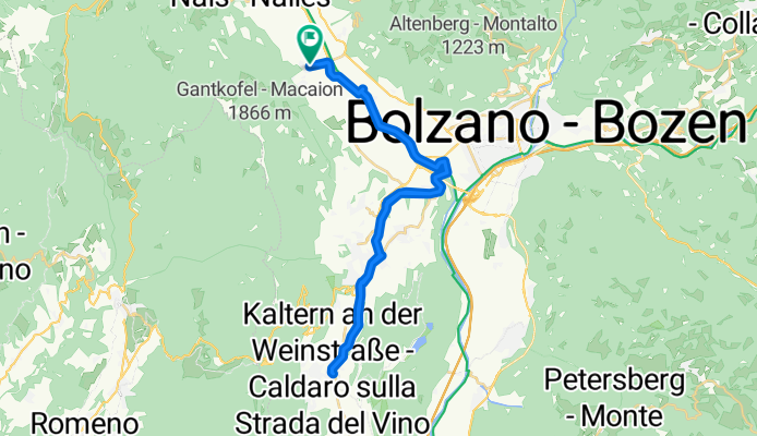
Andrian - Kaltern - Andrian
A cycling route starting in Andriano, Trentino-Alto Adige, Italy.
Overview
About this route
<span style="font-size: 8pt; font-family: Arial; color: black;">Vom Hotel auf dem Etschradweg bis Siegmundskron. Dann auf einer ehemaligen Bahntrasse, durchgehend stark ansteigend nach Epan. Von dort eben weiter nach Kaltern. Nach einer Pause, Rückweg auf der gleichen Route. Auch dieser Bahnradweg führte wieder durch einige gut beleuchtete Tunnels und war durchgehend asphaltiert.</span>
Weitere Touren ab Andrian unter
- -:--
- Duration
- 39 km
- Distance
- 238 m
- Ascent
- 238 m
- Descent
- ---
- Avg. speed
- ---
- Avg. speed
Route quality
Waytypes & surfaces along the route
Waytypes
Cycleway
23.4 km
(60 %)
Quiet road
6.7 km
(17 %)
Surfaces
Paved
34.4 km
(88 %)
Unpaved
0.2 km
(<1 %)
Asphalt
34.3 km
(88 %)
Gravel
0.2 km
(<1 %)
Continue with Bikemap
Use, edit, or download this cycling route
You would like to ride Andrian - Kaltern - Andrian or customize it for your own trip? Here is what you can do with this Bikemap route:
Free features
- Save this route as favorite or in collections
- Copy & plan your own version of this route
- Sync your route with Garmin or Wahoo
Premium features
Free trial for 3 days, or one-time payment. More about Bikemap Premium.
- Navigate this route on iOS & Android
- Export a GPX / KML file of this route
- Create your custom printout (try it for free)
- Download this route for offline navigation
Discover more Premium features.
Get Bikemap PremiumFrom our community
Other popular routes starting in Andriano
 AXS Tour de Alps 2009 - Stage 10°
- Distance
- 206.8 km
- Ascent
- 5,224 m
- Descent
- 4,463 m
- Location
- Andriano, Trentino-Alto Adige, Italy
 Wolfsturm nachSt.Apollonia
- Distance
- 15.1 km
- Ascent
- 3,383 m
- Descent
- 3,430 m
- Location
- Andriano, Trentino-Alto Adige, Italy
 Andrian - Forst - Lana - Andrian
- Distance
- 50.9 km
- Ascent
- 273 m
- Descent
- 274 m
- Location
- Andriano, Trentino-Alto Adige, Italy
 Andrian... Montiggler See MTB 2
- Distance
- 24.2 km
- Ascent
- 746 m
- Descent
- 497 m
- Location
- Andriano, Trentino-Alto Adige, Italy
 Schlern-Blick
- Distance
- 82.2 km
- Ascent
- 1,159 m
- Descent
- 1,170 m
- Location
- Andriano, Trentino-Alto Adige, Italy
 Andrian-Lana-Technikmuseum
- Distance
- 37.5 km
- Ascent
- 32 m
- Descent
- 32 m
- Location
- Andriano, Trentino-Alto Adige, Italy
 Adrian-Vöran-Meran-Adrian
- Distance
- 60.9 km
- Ascent
- 1,433 m
- Descent
- 1,433 m
- Location
- Andriano, Trentino-Alto Adige, Italy
 Adrian-Mendelpass-Gampenjoch-Adrian
- Distance
- 81.5 km
- Ascent
- 1,697 m
- Descent
- 1,697 m
- Location
- Andriano, Trentino-Alto Adige, Italy
Open it in the app