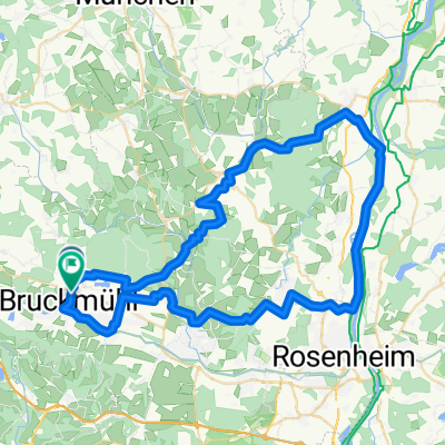
Bruckmühl bis Stephanskirchen Gasthof Antretter
A cycling route starting in Bruckmühl, Bavaria, Germany.
Overview
About this route
- 2 h 55 min
- Duration
- 48.8 km
- Distance
- 111 m
- Ascent
- 112 m
- Descent
- 16.7 km/h
- Avg. speed
- 505 m
- Max. altitude
Route quality
Waytypes & surfaces along the route
Waytypes
Path
30.7 km
(63 %)
Quiet road
14.1 km
(29 %)
Surfaces
Paved
38.5 km
(79 %)
Unpaved
8.8 km
(18 %)
Asphalt
37.1 km
(76 %)
Loose gravel
7.8 km
(16 %)
Continue with Bikemap
Use, edit, or download this cycling route
You would like to ride Bruckmühl bis Stephanskirchen Gasthof Antretter or customize it for your own trip? Here is what you can do with this Bikemap route:
Free features
- Save this route as favorite or in collections
- Copy & plan your own version of this route
- Sync your route with Garmin or Wahoo
Premium features
Free trial for 3 days, or one-time payment. More about Bikemap Premium.
- Navigate this route on iOS & Android
- Export a GPX / KML file of this route
- Create your custom printout (try it for free)
- Download this route for offline navigation
Discover more Premium features.
Get Bikemap PremiumFrom our community
Other popular routes starting in Bruckmühl
Bruckmühl bis Stephanskirchen Gasthof Antretter- Distance
- 48.8 km
- Ascent
- 111 m
- Descent
- 112 m
- Location
- Bruckmühl, Bavaria, Germany
Moderate Route Irschenberg- Distance
- 33.8 km
- Ascent
- 474 m
- Descent
- 474 m
- Location
- Bruckmühl, Bavaria, Germany
Bruckmühl - Irschenberg - Janoschrunde- Distance
- 29.8 km
- Ascent
- 255 m
- Descent
- 255 m
- Location
- Bruckmühl, Bavaria, Germany
RO13 11, Bruckmühl nach RO13 11, Bruckmühl- Distance
- 42.4 km
- Ascent
- 294 m
- Descent
- 340 m
- Location
- Bruckmühl, Bavaria, Germany
Kleine Mangfall Runde- Distance
- 10.7 km
- Ascent
- 25 m
- Descent
- 28 m
- Location
- Bruckmühl, Bavaria, Germany
Bruckmühl - Irschenberg - Janoschrunde- Distance
- 29.8 km
- Ascent
- 320 m
- Descent
- 320 m
- Location
- Bruckmühl, Bavaria, Germany
Mangfallschleife- Distance
- 44 km
- Ascent
- 561 m
- Descent
- 561 m
- Location
- Bruckmühl, Bavaria, Germany
Bruckmühl Tunt Rott RDG Ottob 65 km 320hm- Distance
- 64.2 km
- Ascent
- 207 m
- Descent
- 205 m
- Location
- Bruckmühl, Bavaria, Germany
Open it in the app


