

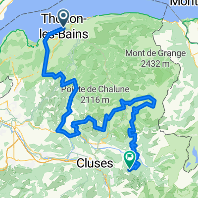
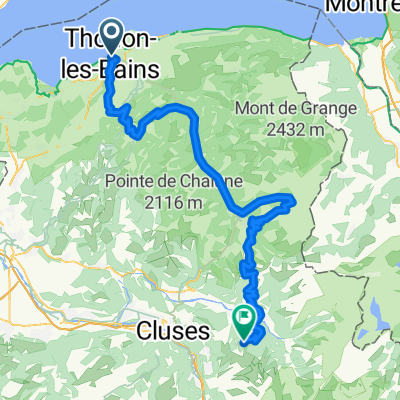
Thonon nach Le Bouveret
A cycling route starting in Thonon-les-Bains, Auvergne-Rhône-Alpes, France.
Overview
About this route
- 2 h 20 min
- Duration
- 38.2 km
- Distance
- 784 m
- Ascent
- 842 m
- Descent
- 16.3 km/h
- Avg. speed
- 577 m
- Max. altitude
Route quality
Waytypes & surfaces along the route
Waytypes
Quiet road
15.6 km
(41 %)
Road
9.5 km
(25 %)
Surfaces
Paved
25.2 km
(66 %)
Unpaved
1.9 km
(5 %)
Asphalt
24.4 km
(64 %)
Gravel
1.9 km
(5 %)
Continue with Bikemap
Use, edit, or download this cycling route
You would like to ride Thonon nach Le Bouveret or customize it for your own trip? Here is what you can do with this Bikemap route:
Free features
- Save this route as favorite or in collections
- Copy & plan your own version of this route
- Sync your route with Garmin or Wahoo
Premium features
Free trial for 3 days, or one-time payment. More about Bikemap Premium.
- Navigate this route on iOS & Android
- Export a GPX / KML file of this route
- Create your custom printout (try it for free)
- Download this route for offline navigation
Discover more Premium features.
Get Bikemap PremiumFrom our community
Other popular routes starting in Thonon-les-Bains
 From Thonon-Les-Bains to Samoëns
- Distance
- 152.9 km
- Ascent
- 6,060 m
- Descent
- 4,867 m
- Location
- Thonon-les-Bains, Auvergne-Rhône-Alpes, France
 Thonon - Geneve
- Distance
- 45.3 km
- Ascent
- 194 m
- Descent
- 252 m
- Location
- Thonon-les-Bains, Auvergne-Rhône-Alpes, France
 From Thonon-Les-Bains to Samoëns
- Distance
- 103.4 km
- Ascent
- 4,489 m
- Descent
- 3,302 m
- Location
- Thonon-les-Bains, Auvergne-Rhône-Alpes, France
 Unbenannte Route
- Distance
- 775.3 km
- Ascent
- 6,396 m
- Descent
- 6,805 m
- Location
- Thonon-les-Bains, Auvergne-Rhône-Alpes, France
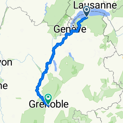 Impasse des Mouettes, Thonon-les-Bains nach Rue Beyle-Stendhal, Grenoble
- Distance
- 228.8 km
- Ascent
- 2,527 m
- Descent
- 2,693 m
- Location
- Thonon-les-Bains, Auvergne-Rhône-Alpes, France
 Thonon nach Le Bouveret
- Distance
- 38.2 km
- Ascent
- 784 m
- Descent
- 842 m
- Location
- Thonon-les-Bains, Auvergne-Rhône-Alpes, France
 col de cou
- Distance
- 50.1 km
- Ascent
- 862 m
- Descent
- 862 m
- Location
- Thonon-les-Bains, Auvergne-Rhône-Alpes, France
 Thonon - Maladiere - Chateaux - Singles - Thonon!
- Distance
- 23.3 km
- Ascent
- 457 m
- Descent
- 457 m
- Location
- Thonon-les-Bains, Auvergne-Rhône-Alpes, France
Open it in the app