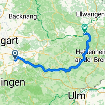
Schönbuch - Deckenpfronn - BB
A cycling route starting in Unterensingen, Baden-Württemberg, Germany.
Overview
About this route
einige sehr schöne Abschnitte, insgesamt aber schlechte Straßen und viel Verkehr!
ab Waldenbuch noh +20km durchs Aichtal bis zum Start.
- -:--
- Duration
- 82.9 km
- Distance
- 642 m
- Ascent
- 557 m
- Descent
- ---
- Avg. speed
- ---
- Avg. speed
Route quality
Waytypes & surfaces along the route
Waytypes
Road
37.9 km
(46 %)
Busy road
26.8 km
(32 %)
Surfaces
Paved
77.4 km
(93 %)
Unpaved
0.3 km
(<1 %)
Asphalt
74.8 km
(90 %)
Concrete
1.2 km
(1 %)
Continue with Bikemap
Use, edit, or download this cycling route
You would like to ride Schönbuch - Deckenpfronn - BB or customize it for your own trip? Here is what you can do with this Bikemap route:
Free features
- Save this route as favorite or in collections
- Copy & plan your own version of this route
- Sync your route with Garmin or Wahoo
Premium features
Free trial for 3 days, or one-time payment. More about Bikemap Premium.
- Navigate this route on iOS & Android
- Export a GPX / KML file of this route
- Create your custom printout (try it for free)
- Download this route for offline navigation
Discover more Premium features.
Get Bikemap PremiumFrom our community
Other popular routes starting in Unterensingen
- Unterensingen - Untersteinbach
- Distance
- 85.5 km
- Ascent
- 1,578 m
- Descent
- 1,599 m
- Location
- Unterensingen, Baden-Württemberg, Germany
- Round Trip Unterensingen-Esslingen
- Distance
- 41.2 km
- Ascent
- 96 m
- Descent
- 96 m
- Location
- Unterensingen, Baden-Württemberg, Germany
- U'ensingen - Lautlingen
- Distance
- 92.8 km
- Ascent
- 1,136 m
- Descent
- 720 m
- Location
- Unterensingen, Baden-Württemberg, Germany
- Hometour
- Distance
- 5.6 km
- Ascent
- 32 m
- Descent
- 50 m
- Location
- Unterensingen, Baden-Württemberg, Germany
- KLeine Feierabendrunde 50km
- Distance
- 48.8 km
- Ascent
- 663 m
- Descent
- 651 m
- Location
- Unterensingen, Baden-Württemberg, Germany
- Neckar Richtung Metzingen
- Distance
- 39.5 km
- Ascent
- 156 m
- Descent
- 156 m
- Location
- Unterensingen, Baden-Württemberg, Germany
- Köngen Nürtingen Käppele
- Distance
- 26.8 km
- Ascent
- 342 m
- Descent
- 342 m
- Location
- Unterensingen, Baden-Württemberg, Germany
- Ehestetten ROSE.
- Distance
- 63.5 km
- Ascent
- 657 m
- Descent
- 206 m
- Location
- Unterensingen, Baden-Württemberg, Germany
Open it in the app