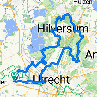
Route in Harmelen
A cycling route starting in Montfoort, Provincie Utrecht, Netherlands.
Overview
About this route
- 7 h 17 min
- Duration
- 119.6 km
- Distance
- 215 m
- Ascent
- 213 m
- Descent
- 16.4 km/h
- Avg. speed
- 33 m
- Avg. speed
Route quality
Waytypes & surfaces along the route
Waytypes
Cycleway
65.7 km
(55 %)
Quiet road
38.9 km
(32 %)
Surfaces
Paved
57 km
(48 %)
Unpaved
24.7 km
(21 %)
Asphalt
51.3 km
(43 %)
Loose gravel
21.8 km
(18 %)
Continue with Bikemap
Use, edit, or download this cycling route
You would like to ride Route in Harmelen or customize it for your own trip? Here is what you can do with this Bikemap route:
Free features
- Save this route as favorite or in collections
- Copy & plan your own version of this route
- Sync your route with Garmin or Wahoo
Premium features
Free trial for 3 days, or one-time payment. More about Bikemap Premium.
- Navigate this route on iOS & Android
- Export a GPX / KML file of this route
- Create your custom printout (try it for free)
- Download this route for offline navigation
Discover more Premium features.
Get Bikemap PremiumFrom our community
Other popular routes starting in Montfoort
- Route in Harmelen
- Distance
- 119.6 km
- Ascent
- 215 m
- Descent
- 213 m
- Location
- Montfoort, Provincie Utrecht, Netherlands
- Route in Harmelen
- Distance
- 97.1 km
- Ascent
- 197 m
- Descent
- 197 m
- Location
- Montfoort, Provincie Utrecht, Netherlands
- Amelisweerd
- Distance
- 34.6 km
- Ascent
- 5 m
- Descent
- 4 m
- Location
- Montfoort, Provincie Utrecht, Netherlands
- oudewater, haastrecht, ijsselstein 60 km
- Distance
- 59.1 km
- Ascent
- 0 m
- Descent
- 0 m
- Location
- Montfoort, Provincie Utrecht, Netherlands
- Rondje: IJsselstein, Montfoort, Harmelen.
- Distance
- 33.6 km
- Ascent
- 4 m
- Descent
- 4 m
- Location
- Montfoort, Provincie Utrecht, Netherlands
- Rondje Montfoort-Hogebrug 50km
- Distance
- 49.4 km
- Ascent
- 0 m
- Descent
- 0 m
- Location
- Montfoort, Provincie Utrecht, Netherlands
- Route in Harmelen
- Distance
- 85.2 km
- Ascent
- 146 m
- Descent
- 147 m
- Location
- Montfoort, Provincie Utrecht, Netherlands
- 2017 07 06 Willeskop route
- Distance
- 51.2 km
- Ascent
- 0 m
- Descent
- 0 m
- Location
- Montfoort, Provincie Utrecht, Netherlands
Open it in the app