

CH01 -Uznach nach Bad Ragaz
A cycling route starting in Uznach, Canton of St. Gallen, Switzerland.
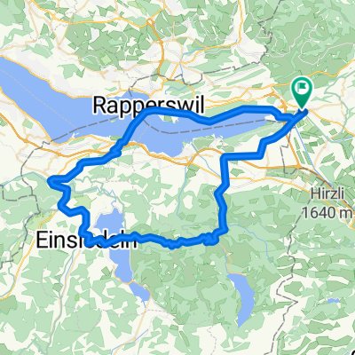
Overview
About this route
Stopover: approx. 26.5 km at the brewery in Mühlehorn; alternative approx. 29.2 km Sagibeiz at Walensee in Murg or approx. 34.6 km Bistro Hafen West in Mols. Afternoon: approx. 52 km Migrolino supermarket in Sargans.
- 4 h 5 min
- Duration
- 63.3 km
- Distance
- 1,111 m
- Ascent
- 1,085 m
- Descent
- 15.5 km/h
- Avg. speed
- 617 m
- Max. altitude
Route quality
Waytypes & surfaces along the route
Waytypes
Quiet road
25.3 km
(40 %)
Track
12 km
(19 %)
Surfaces
Paved
56.3 km
(89 %)
Unpaved
5.1 km
(8 %)
Asphalt
54.4 km
(86 %)
Loose gravel
3.8 km
(6 %)
Continue with Bikemap
Use, edit, or download this cycling route
You would like to ride CH01 -Uznach nach Bad Ragaz or customize it for your own trip? Here is what you can do with this Bikemap route:
Free features
- Save this route as favorite or in collections
- Copy & plan your own version of this route
- Sync your route with Garmin or Wahoo
Premium features
Free trial for 3 days, or one-time payment. More about Bikemap Premium.
- Navigate this route on iOS & Android
- Export a GPX / KML file of this route
- Create your custom printout (try it for free)
- Download this route for offline navigation
Discover more Premium features.
Get Bikemap PremiumFrom our community
Other popular routes starting in Uznach
 Reichenburg (Ussbergwald)
- Distance
- 30.3 km
- Ascent
- 757 m
- Descent
- 756 m
- Location
- Uznach, Canton of St. Gallen, Switzerland
 grynau - gäsi - grynau
- Distance
- 37 km
- Ascent
- 32 m
- Descent
- 32 m
- Location
- Uznach, Canton of St. Gallen, Switzerland
 Uznach-Neuhaus-Wurmsbach-Uznach
- Distance
- 24 km
- Ascent
- 303 m
- Descent
- 303 m
- Location
- Uznach, Canton of St. Gallen, Switzerland
 Route von ?7›^?
- Distance
- 11.1 km
- Ascent
- 780 m
- Descent
- 0 m
- Location
- Uznach, Canton of St. Gallen, Switzerland
 Einzelzeitfahren Linthebene 20km
- Distance
- 19.8 km
- Ascent
- 43 m
- Descent
- 44 m
- Location
- Uznach, Canton of St. Gallen, Switzerland
 65 Uznach - Sattelegg - Uznach Challenge 4
- Distance
- 65.3 km
- Ascent
- 863 m
- Descent
- 861 m
- Location
- Uznach, Canton of St. Gallen, Switzerland
 CH01 -Uznach nach Bad Ragaz
- Distance
- 63.3 km
- Ascent
- 1,111 m
- Descent
- 1,085 m
- Location
- Uznach, Canton of St. Gallen, Switzerland
 Rundtour Uznach, Rüeterswil, Goldingen
- Distance
- 19.6 km
- Ascent
- 451 m
- Descent
- 452 m
- Location
- Uznach, Canton of St. Gallen, Switzerland
Open it in the app