
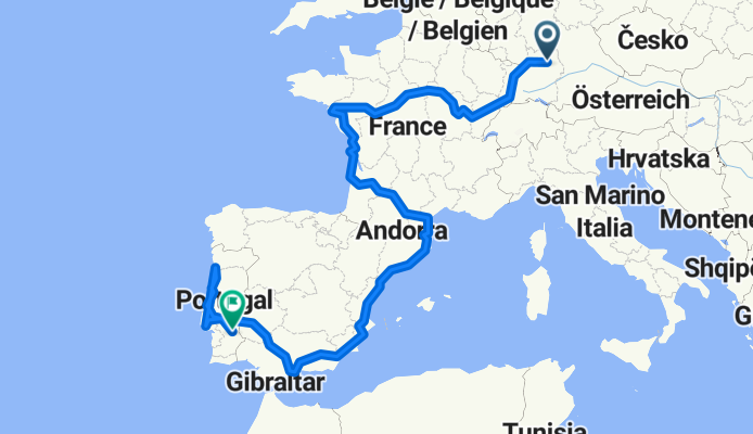
Roadtrip
A cycling route starting in Mainhardt, Baden-Württemberg, Germany.
Overview
About this route
- 327 h 2 min
- Duration
- 5,317.6 km
- Distance
- 34,731 m
- Ascent
- 35,051 m
- Descent
- 16.3 km/h
- Avg. speed
- 1,301 m
- Max. altitude
Route quality
Waytypes & surfaces along the route
Waytypes
Quiet road
1,604.4 km
(30 %)
Cycleway
1,332.5 km
(25 %)
Surfaces
Paved
2,535.3 km
(48 %)
Unpaved
486.9 km
(9 %)
Asphalt
2,143.3 km
(40 %)
Paved (undefined)
301 km
(6 %)
Continue with Bikemap
Use, edit, or download this cycling route
You would like to ride Roadtrip or customize it for your own trip? Here is what you can do with this Bikemap route:
Free features
- Save this route as favorite or in collections
- Copy & plan your own version of this route
- Split it into stages to create a multi-day tour
- Sync your route with Garmin or Wahoo
Premium features
Free trial for 3 days, or one-time payment. More about Bikemap Premium.
- Navigate this route on iOS & Android
- Export a GPX / KML file of this route
- Create your custom printout (try it for free)
- Download this route for offline navigation
Discover more Premium features.
Get Bikemap PremiumFrom our community
Other popular routes starting in Mainhardt
 MTB SW Teil 3 Tough Timber Lake
- Distance
- 28.4 km
- Ascent
- 495 m
- Descent
- 495 m
- Location
- Mainhardt, Baden-Württemberg, Germany
 Landheg-Tour-West
- Distance
- 40.2 km
- Ascent
- 473 m
- Descent
- 473 m
- Location
- Mainhardt, Baden-Württemberg, Germany
 B39 8, Mainhardt nach Löwensteiner Straße 8, Mainhardt
- Distance
- 29 km
- Ascent
- 222 m
- Descent
- 227 m
- Location
- Mainhardt, Baden-Württemberg, Germany
 Route nach Im Viertel 6, Mainhardt
- Distance
- 25.4 km
- Ascent
- 270 m
- Descent
- 228 m
- Location
- Mainhardt, Baden-Württemberg, Germany
 Laukenmühle - Neuhütten -Brettach
- Distance
- 13.5 km
- Ascent
- 275 m
- Descent
- 279 m
- Location
- Mainhardt, Baden-Württemberg, Germany
 Mainhardt Tour 7
- Distance
- 33 km
- Ascent
- 323 m
- Descent
- 322 m
- Location
- Mainhardt, Baden-Württemberg, Germany
 Roadtrip
- Distance
- 5,317.6 km
- Ascent
- 34,731 m
- Descent
- 35,051 m
- Location
- Mainhardt, Baden-Württemberg, Germany
 Limes-Wanderweg Grab
- Distance
- 5.5 km
- Ascent
- 116 m
- Descent
- 117 m
- Location
- Mainhardt, Baden-Württemberg, Germany
Open it in the app