
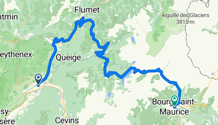
EDT 2025 officiel Bourg
A cycling route starting in Grignon, Auvergne-Rhône-Alpes, France.
Overview
About this route
- 8 h 29 min
- Duration
- 103.3 km
- Distance
- 4,088 m
- Ascent
- 3,602 m
- Descent
- 12.2 km/h
- Avg. speed
- 1,974 m
- Max. altitude
Route quality
Waytypes & surfaces along the route
Waytypes
Road
27.9 km
(27 %)
Living street
4.1 km
(4 %)
Surfaces
Paved
85.7 km
(83 %)
Asphalt
85.7 km
(83 %)
Undefined
17.6 km
(17 %)
Continue with Bikemap
Use, edit, or download this cycling route
You would like to ride EDT 2025 officiel Bourg or customize it for your own trip? Here is what you can do with this Bikemap route:
Free features
- Save this route as favorite or in collections
- Copy & plan your own version of this route
- Split it into stages to create a multi-day tour
- Sync your route with Garmin or Wahoo
Premium features
Free trial for 3 days, or one-time payment. More about Bikemap Premium.
- Navigate this route on iOS & Android
- Export a GPX / KML file of this route
- Create your custom printout (try it for free)
- Download this route for offline navigation
Discover more Premium features.
Get Bikemap PremiumFrom our community
Other popular routes starting in Grignon
 G2N D2 Base Route
- Distance
- 98.1 km
- Ascent
- 2,178 m
- Descent
- 1,786 m
- Location
- Grignon, Auvergne-Rhône-Alpes, France
 EDT 2025 officiel Bourg
- Distance
- 103.3 km
- Ascent
- 4,088 m
- Descent
- 3,602 m
- Location
- Grignon, Auvergne-Rhône-Alpes, France
 EDT 2025 officiel beaufort
- Distance
- 79.1 km
- Ascent
- 2,479 m
- Descent
- 2,477 m
- Location
- Grignon, Auvergne-Rhône-Alpes, France
 12. Albertville / La Toussuire - Les Sybelles
- Distance
- 154.2 km
- Ascent
- 4,637 m
- Descent
- 3,272 m
- Location
- Grignon, Auvergne-Rhône-Alpes, France
 8 agosto 2023
- Distance
- 52.4 km
- Ascent
- 603 m
- Descent
- 313 m
- Location
- Grignon, Auvergne-Rhône-Alpes, France
 Bisanne
- Distance
- 91.5 km
- Ascent
- 2,617 m
- Descent
- 2,615 m
- Location
- Grignon, Auvergne-Rhône-Alpes, France
 EDT 2025 officiel full
- Distance
- 133.1 km
- Ascent
- 5,667 m
- Descent
- 3,879 m
- Location
- Grignon, Auvergne-Rhône-Alpes, France
 Albertville-Saint Tropez
- Distance
- 490.2 km
- Ascent
- 6,314 m
- Descent
- 6,642 m
- Location
- Grignon, Auvergne-Rhône-Alpes, France
Open it in the app