

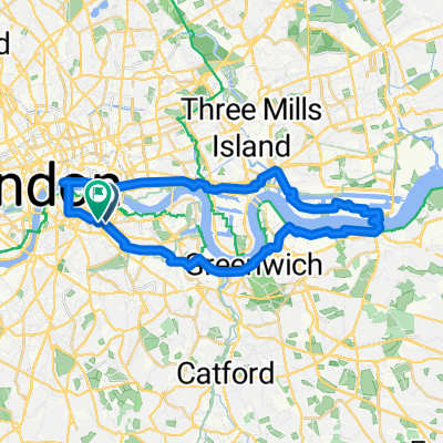
a ferry nice ride
A cycling route starting in Kennington, England, United Kingdom.
Overview
About this route
- 2 h 11 min
- Duration
- 32.4 km
- Distance
- 104 m
- Ascent
- 105 m
- Descent
- 14.8 km/h
- Avg. speed
- 29 m
- Max. altitude

Route quality
Waytypes & surfaces along the route
Waytypes
Cycleway
19.8 km
(61 %)
Quiet road
9.1 km
(28 %)
Surfaces
Paved
25.6 km
(79 %)
Asphalt
22.4 km
(69 %)
Paved (undefined)
2.6 km
(8 %)
Continue with Bikemap
Use, edit, or download this cycling route
You would like to ride a ferry nice ride or customize it for your own trip? Here is what you can do with this Bikemap route:
Free features
- Save this route as favorite or in collections
- Copy & plan your own version of this route
- Sync your route with Garmin or Wahoo
Premium features
Free trial for 3 days, or one-time payment. More about Bikemap Premium.
- Navigate this route on iOS & Android
- Export a GPX / KML file of this route
- Create your custom printout (try it for free)
- Download this route for offline navigation
Discover more Premium features.
Get Bikemap PremiumFrom our community
Other popular routes starting in Kennington
 a ferry nice ride
- Distance
- 32.4 km
- Ascent
- 104 m
- Descent
- 105 m
- Location
- Kennington, England, United Kingdom
 East London, innit
- Distance
- 39.9 km
- Ascent
- 91 m
- Descent
- 89 m
- Location
- Kennington, England, United Kingdom
 East Street
- Distance
- 7.9 km
- Ascent
- 21 m
- Descent
- 20 m
- Location
- Kennington, England, United Kingdom
 Kennington to Windsor
- Distance
- 68.5 km
- Ascent
- 195 m
- Descent
- 180 m
- Location
- Kennington, England, United Kingdom
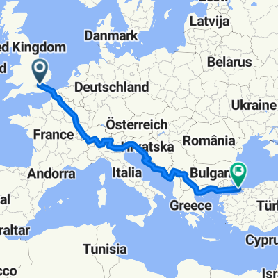 Pan_Europe
- Distance
- 4,138.8 km
- Ascent
- 6,030 m
- Descent
- 6,029 m
- Location
- Kennington, England, United Kingdom
 Long Way Home
- Distance
- 24.7 km
- Ascent
- 145 m
- Descent
- 131 m
- Location
- Kennington, England, United Kingdom
 Click London - Photo Cycle Southeast LDN - June 14
- Distance
- 12.2 km
- Ascent
- 52 m
- Descent
- 51 m
- Location
- Kennington, England, United Kingdom
 Brighton Stammer Park
- Distance
- 78.9 km
- Ascent
- 641 m
- Descent
- 587 m
- Location
- Kennington, England, United Kingdom
Open it in the app