
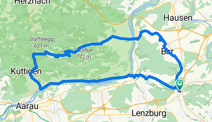
250511 Staffelegg Runde
A cycling route starting in Othmarsingen, Canton of Aargau, Switzerland.
Overview
About this route
- 2 h 20 min
- Duration
- 37.6 km
- Distance
- 497 m
- Ascent
- 498 m
- Descent
- 16.1 km/h
- Avg. speed
- 671 m
- Max. altitude

Route photos


Route quality
Waytypes & surfaces along the route
Waytypes
Quiet road
11.3 km
(30 %)
Track
9.3 km
(25 %)
Surfaces
Paved
21.3 km
(57 %)
Unpaved
6.4 km
(17 %)
Asphalt
21 km
(56 %)
Gravel
6.1 km
(16 %)
Continue with Bikemap
Use, edit, or download this cycling route
You would like to ride 250511 Staffelegg Runde or customize it for your own trip? Here is what you can do with this Bikemap route:
Free features
- Save this route as favorite or in collections
- Copy & plan your own version of this route
- Sync your route with Garmin or Wahoo
Premium features
Free trial for 3 days, or one-time payment. More about Bikemap Premium.
- Navigate this route on iOS & Android
- Export a GPX / KML file of this route
- Create your custom printout (try it for free)
- Download this route for offline navigation
Discover more Premium features.
Get Bikemap PremiumFrom our community
Other popular routes starting in Othmarsingen
 an der Aare ist's schön
- Distance
- 27.2 km
- Ascent
- 107 m
- Descent
- 101 m
- Location
- Othmarsingen, Canton of Aargau, Switzerland
 Mägenwil-Hägglingen-Wohlenschwil-Mägenwil
- Distance
- 11.3 km
- Ascent
- 315 m
- Descent
- 316 m
- Location
- Othmarsingen, Canton of Aargau, Switzerland
 Buchenweg 2, Othmarsingen nach Buchenweg 2, Othmarsingen
- Distance
- 31.4 km
- Ascent
- 457 m
- Descent
- 446 m
- Location
- Othmarsingen, Canton of Aargau, Switzerland
 Einfache Fahrt in Mägenwil
- Distance
- 14.9 km
- Ascent
- 189 m
- Descent
- 187 m
- Location
- Othmarsingen, Canton of Aargau, Switzerland
 Möriken-Niederlenz
- Distance
- 14.2 km
- Ascent
- 151 m
- Descent
- 141 m
- Location
- Othmarsingen, Canton of Aargau, Switzerland
 200620 Othmarsingen Aarau retour
- Distance
- 33.3 km
- Ascent
- 144 m
- Descent
- 143 m
- Location
- Othmarsingen, Canton of Aargau, Switzerland
 Reuss-Zugersee-Emmenbrücke
- Distance
- 63.8 km
- Ascent
- 228 m
- Descent
- 199 m
- Location
- Othmarsingen, Canton of Aargau, Switzerland
 Hochdorf-Sempach-Sursee-retour CLONED FROM ROUTE 1491245
- Distance
- 102.3 km
- Ascent
- 760 m
- Descent
- 760 m
- Location
- Othmarsingen, Canton of Aargau, Switzerland
Open it in the app