
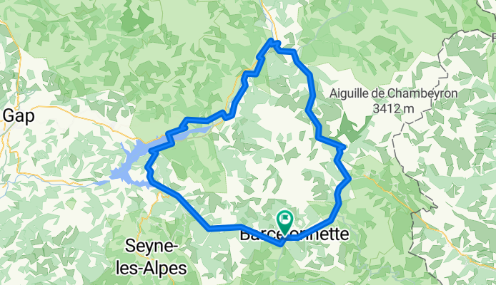
Route in La Condamine-Châtelard
A cycling route starting in Barcelonnette, Provence-Alpes-Côte d'Azur Region, France.
Overview
About this route
- 9 h 4 min
- Duration
- 140.2 km
- Distance
- 5,301 m
- Ascent
- 5,303 m
- Descent
- 15.4 km/h
- Avg. speed
- 2,108 m
- Max. altitude

Route quality
Waytypes & surfaces along the route
Waytypes
Road
21 km
(15 %)
Quiet road
4.2 km
(3 %)
Surfaces
Paved
85.5 km
(61 %)
Asphalt
82.7 km
(59 %)
Paved (undefined)
2.8 km
(2 %)
Undefined
54.7 km
(39 %)
Continue with Bikemap
Use, edit, or download this cycling route
You would like to ride Route in La Condamine-Châtelard or customize it for your own trip? Here is what you can do with this Bikemap route:
Free features
- Save this route as favorite or in collections
- Copy & plan your own version of this route
- Split it into stages to create a multi-day tour
- Sync your route with Garmin or Wahoo
Premium features
Free trial for 3 days, or one-time payment. More about Bikemap Premium.
- Navigate this route on iOS & Android
- Export a GPX / KML file of this route
- Create your custom printout (try it for free)
- Download this route for offline navigation
Discover more Premium features.
Get Bikemap PremiumFrom our community
Other popular routes starting in Barcelonnette
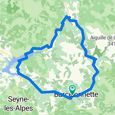 Route in La Condamine-Châtelard
- Distance
- 140.2 km
- Ascent
- 5,301 m
- Descent
- 5,303 m
- Location
- Barcelonnette, Provence-Alpes-Côte d'Azur Region, France
 FR Alpes Circuit des 3 Cols
- Distance
- 116.8 km
- Ascent
- 3,133 m
- Descent
- 3,133 m
- Location
- Barcelonnette, Provence-Alpes-Côte d'Azur Region, France
 Allauch 22 Tag 10 Do 9.6.
- Distance
- 89.6 km
- Ascent
- 2,035 m
- Descent
- 2,501 m
- Location
- Barcelonnette, Provence-Alpes-Côte d'Azur Region, France
 Allauch 8. Etappe
- Distance
- 92.5 km
- Ascent
- 1,242 m
- Descent
- 1,623 m
- Location
- Barcelonnette, Provence-Alpes-Côte d'Azur Region, France
 RR Dingo Guillestre D6 123k
- Distance
- 122.3 km
- Ascent
- 6,484 m
- Descent
- 6,489 m
- Location
- Barcelonnette, Provence-Alpes-Côte d'Azur Region, France
 Tour du Mercantour (remorque, solo)
- Distance
- 436.6 km
- Ascent
- 8,033 m
- Descent
- 8,036 m
- Location
- Barcelonnette, Provence-Alpes-Côte d'Azur Region, France
 Vars Pontis Jean
- Distance
- 122.3 km
- Ascent
- 1,868 m
- Descent
- 1,873 m
- Location
- Barcelonnette, Provence-Alpes-Côte d'Azur Region, France
 3 Cols (Alos, Champs, Cayolle)
- Distance
- 115.2 km
- Ascent
- 3,187 m
- Descent
- 3,188 m
- Location
- Barcelonnette, Provence-Alpes-Côte d'Azur Region, France
Open it in the app