

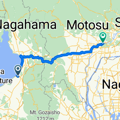
八坂町, 彦根市へ西今町, 彦根市
A cycling route starting in Hikone, Shiga Prefecture, Japan.
Overview
About this route
- 20 min
- Duration
- 5.4 km
- Distance
- 22 m
- Ascent
- 11 m
- Descent
- 15.9 km/h
- Avg. speed
- 104 m
- Max. altitude
Route quality
Waytypes & surfaces along the route
Waytypes
Quiet road
3.8 km
(70 %)
Access road
0.8 km
(15 %)
Surfaces
Paved
0.5 km
(9 %)
Paved (undefined)
0.5 km
(9 %)
Undefined
4.9 km
(91 %)
Continue with Bikemap
Use, edit, or download this cycling route
You would like to ride 八坂町, 彦根市へ西今町, 彦根市 or customize it for your own trip? Here is what you can do with this Bikemap route:
Free features
- Save this route as favorite or in collections
- Copy & plan your own version of this route
- Sync your route with Garmin or Wahoo
Premium features
Free trial for 3 days, or one-time payment. More about Bikemap Premium.
- Navigate this route on iOS & Android
- Export a GPX / KML file of this route
- Create your custom printout (try it for free)
- Download this route for offline navigation
Discover more Premium features.
Get Bikemap PremiumFrom our community
Other popular routes starting in Hikone
 川瀬馬場町743-6, 彦根市 to 小泉町31, 彦根市
- Distance
- 3.3 km
- Ascent
- 13 m
- Descent
- 4 m
- Location
- Hikone, Shiga Prefecture, Japan
 八坂町, 彦根市へ西今町, 彦根市
- Distance
- 5.4 km
- Ascent
- 22 m
- Descent
- 11 m
- Location
- Hikone, Shiga Prefecture, Japan
 Day 9 Lake Biwa to Kyoto
- Distance
- 76 km
- Ascent
- 250 m
- Descent
- 274 m
- Location
- Hikone, Shiga Prefecture, Japan
 jappo tour day 4
- Distance
- 110.5 km
- Ascent
- 245 m
- Descent
- 325 m
- Location
- Hikone, Shiga Prefecture, Japan
 0821彥根-長濱51km
- Distance
- 51.5 km
- Ascent
- 422 m
- Descent
- 412 m
- Location
- Hikone, Shiga Prefecture, Japan
 Route to Otsu
- Distance
- 75.8 km
- Ascent
- 470 m
- Descent
- 458 m
- Location
- Hikone, Shiga Prefecture, Japan
 Hikone - Kasamatsuchō
- Distance
- 77.4 km
- Ascent
- 516 m
- Descent
- 576 m
- Location
- Hikone, Shiga Prefecture, Japan
 09-06-2013_Day03
- Distance
- 67.4 km
- Ascent
- 253 m
- Descent
- 310 m
- Location
- Hikone, Shiga Prefecture, Japan
Open it in the app