

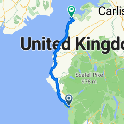
Ravenglass to Newcastle upon Tyne
A cycling route starting in Seascale, England, United Kingdom.
Overview
About this route
- 14 h 10 min
- Duration
- 229.7 km
- Distance
- 1,769 m
- Ascent
- 1,754 m
- Descent
- 16.2 km/h
- Avg. speed
- 262 m
- Max. altitude
Route quality
Waytypes & surfaces along the route
Waytypes
Quiet road
101.1 km
(44 %)
Cycleway
66.6 km
(29 %)
Surfaces
Paved
57.4 km
(25 %)
Unpaved
4.6 km
(2 %)
Asphalt
52.8 km
(23 %)
Paved (undefined)
2.3 km
(1 %)
Continue with Bikemap
Use, edit, or download this cycling route
You would like to ride Ravenglass to Newcastle upon Tyne or customize it for your own trip? Here is what you can do with this Bikemap route:
Free features
- Save this route as favorite or in collections
- Copy & plan your own version of this route
- Split it into stages to create a multi-day tour
- Sync your route with Garmin or Wahoo
Premium features
Free trial for 3 days, or one-time payment. More about Bikemap Premium.
- Navigate this route on iOS & Android
- Export a GPX / KML file of this route
- Create your custom printout (try it for free)
- Download this route for offline navigation
Discover more Premium features.
Get Bikemap PremiumFrom our community
Other popular routes starting in Seascale
 C2C-No-ferry
- Distance
- 242.2 km
- Ascent
- 691 m
- Descent
- 691 m
- Location
- Seascale, England, United Kingdom
 Seascale - Silloth
- Distance
- 79.1 km
- Ascent
- 411 m
- Descent
- 412 m
- Location
- Seascale, England, United Kingdom
 Ravenglass Walk
- Distance
- 8.1 km
- Ascent
- 87 m
- Descent
- 92 m
- Location
- Seascale, England, United Kingdom
 Hadrian's Wall Day 1: Ravenglass to Maryport
- Distance
- 59.3 km
- Ascent
- 537 m
- Descent
- 524 m
- Location
- Seascale, England, United Kingdom
 Hadrians Wall Cycle Route 2011
- Distance
- 288.5 km
- Ascent
- 567 m
- Descent
- 563 m
- Location
- Seascale, England, United Kingdom
 Hadrians Cycle Route new
- Distance
- 282 km
- Ascent
- 597 m
- Descent
- 598 m
- Location
- Seascale, England, United Kingdom
 coast 2 coast 2014
- Distance
- 237.7 km
- Ascent
- 1,415 m
- Descent
- 1,386 m
- Location
- Seascale, England, United Kingdom
 Ravenglass to Newcastle upon Tyne
- Distance
- 229.7 km
- Ascent
- 1,769 m
- Descent
- 1,754 m
- Location
- Seascale, England, United Kingdom
Open it in the app