
6. nap - 6. nap_6. nap - 6. nap_6. nap - Nyírjes - szálláshely
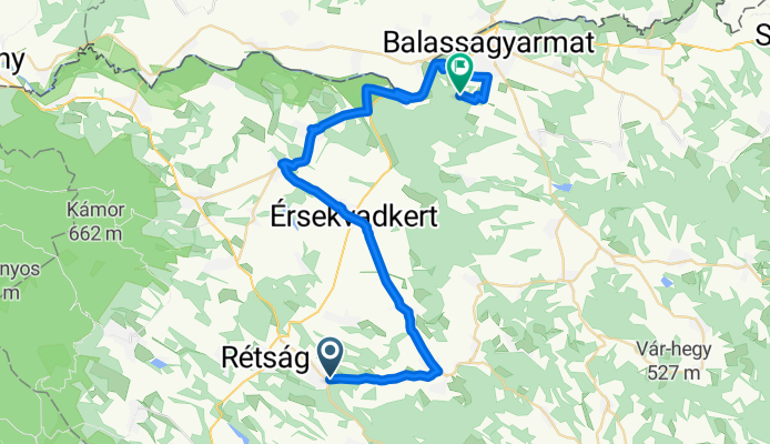
A cycling route starting in Rétság, Nógrád megye, Hungary.
Overview
About this route
The statistic was calculated by the system based on the imported data July 3, 2024, Wednesday 9:05 CEST Distance: 38.9 km Duration: 3 hours, 46 minutes and 28 seconds Average speed: 10.3 km/h Minimum altitude: 52 m Maximum altitude: 190 m Total ascent: 455 m Total descent: 466 m - The statistic was calculated by the system based on the imported data July 3, 2024, Wednesday 14:35 CEST Distance: 7.9 km Duration: 1 hour, 13 minutes and 58 seconds Average speed: 6.4 km/h Minimum altitude: 141 m Maximum altitude: 180 m Total ascent: 27 m Total descent: 39 m
- -:--
- Duration
- 52.3 km
- Distance
- 180 m
- Ascent
- 192 m
- Descent
- ---
- Avg. speed
- 182 m
- Max. altitude

Continue with Bikemap
Use, edit, or download this cycling route
You would like to ride 6. nap - 6. nap_6. nap - 6. nap_6. nap - Nyírjes - szálláshely or customize it for your own trip? Here is what you can do with this Bikemap route:
Free features
- Save this route as favorite or in collections
- Copy & plan your own version of this route
- Sync your route with Garmin or Wahoo
Premium features
Free trial for 3 days, or one-time payment. More about Bikemap Premium.
- Navigate this route on iOS & Android
- Export a GPX / KML file of this route
- Create your custom printout (try it for free)
- Download this route for offline navigation
Discover more Premium features.
Get Bikemap PremiumFrom our community
Other popular routes starting in Rétság
 Bánk-Bp-Tahi-Bánk
- Distance
- 150.5 km
- Ascent
- 425 m
- Descent
- 425 m
- Location
- Rétság, Nógrád megye, Hungary
 Börzsönyi vártúra
- Distance
- 83.5 km
- Ascent
- 867 m
- Descent
- 867 m
- Location
- Rétság, Nógrád megye, Hungary
 Rétság-Szob
- Distance
- 77.2 km
- Ascent
- 441 m
- Descent
- 441 m
- Location
- Rétság, Nógrád megye, Hungary
 Bánk bringás vándor képzés
- Distance
- 38 km
- Ascent
- 786 m
- Descent
- 775 m
- Location
- Rétság, Nógrád megye, Hungary
 Cserhát egy kis Börzsönnyel
- Distance
- 81.9 km
- Ascent
- 758 m
- Descent
- 757 m
- Location
- Rétság, Nógrád megye, Hungary
 Bánk-Nógrádkövesd-Magyarnándor-Bánk kör
- Distance
- 46.9 km
- Ascent
- 324 m
- Descent
- 322 m
- Location
- Rétság, Nógrád megye, Hungary
 Csványos
- Distance
- 41.6 km
- Ascent
- 811 m
- Descent
- 808 m
- Location
- Rétság, Nógrád megye, Hungary
 Bánk-Budapest v2
- Distance
- 75.1 km
- Ascent
- 181 m
- Descent
- 247 m
- Location
- Rétság, Nógrád megye, Hungary
Open it in the app