

Erzsébet - Zugló - Megyeri híd
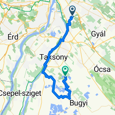
A cycling route starting in Budapest XX. kerület, Budapest, Hungary.
Overview
About this route
- 3 h 34 min
- Duration
- 58.9 km
- Distance
- 214 m
- Ascent
- 213 m
- Descent
- 16.5 km/h
- Avg. speed
- 157 m
- Max. altitude

Route quality
Waytypes & surfaces along the route
Waytypes
Cycleway
26.8 km
(46 %)
Quiet road
16.1 km
(27 %)
Surfaces
Paved
50.6 km
(86 %)
Unpaved
1.4 km
(2 %)
Asphalt
48.5 km
(82 %)
Concrete
1.9 km
(3 %)
Continue with Bikemap
Use, edit, or download this cycling route
You would like to ride Erzsébet - Zugló - Megyeri híd or customize it for your own trip? Here is what you can do with this Bikemap route:
Free features
- Save this route as favorite or in collections
- Copy & plan your own version of this route
- Sync your route with Garmin or Wahoo
Premium features
Free trial for 3 days, or one-time payment. More about Bikemap Premium.
- Navigate this route on iOS & Android
- Export a GPX / KML file of this route
- Create your custom printout (try it for free)
- Download this route for offline navigation
Discover more Premium features.
Get Bikemap PremiumFrom our community
Other popular routes starting in Budapest XX. kerület
 Délegyháza - Rukkel tó
- Distance
- 42.4 km
- Ascent
- 87 m
- Descent
- 107 m
- Location
- Budapest XX. kerület, Budapest, Hungary
 Baross utca, Budapest - Baross utca, Budapest
- Distance
- 23.8 km
- Ascent
- 99 m
- Descent
- 101 m
- Location
- Budapest XX. kerület, Budapest, Hungary
 Big Route
- Distance
- 58.7 km
- Ascent
- 60 m
- Descent
- 60 m
- Location
- Budapest XX. kerület, Budapest, Hungary
 Csepel-Csobánka
- Distance
- 35.2 km
- Ascent
- 170 m
- Descent
- 79 m
- Location
- Budapest XX. kerület, Budapest, Hungary
 Route in Budapest
- Distance
- 11.8 km
- Ascent
- 28 m
- Descent
- 29 m
- Location
- Budapest XX. kerület, Budapest, Hungary
 Erzsébet - Ráckeve - Erzsébet
- Distance
- 75.3 km
- Ascent
- 133 m
- Descent
- 133 m
- Location
- Budapest XX. kerület, Budapest, Hungary
 Bp-Dömsöd-Bugyi-Ócsa-Bp
- Distance
- 97.4 km
- Ascent
- 56 m
- Descent
- 51 m
- Location
- Budapest XX. kerület, Budapest, Hungary
 Erzsébet - Róna utca
- Distance
- 13.3 km
- Ascent
- 17 m
- Descent
- 14 m
- Location
- Budapest XX. kerület, Budapest, Hungary
Open it in the app