

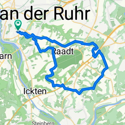
Route in Mülheim an der Ruhr
A cycling route starting in Mülheim, North Rhine-Westphalia, Germany.
Overview
About this route
- 1 h 24 min
- Duration
- 22.8 km
- Distance
- 120 m
- Ascent
- 121 m
- Descent
- 16.4 km/h
- Avg. speed
- 81 m
- Max. altitude

Route quality
Waytypes & surfaces along the route
Waytypes
Track
13.5 km
(59 %)
Path
3.2 km
(14 %)
Surfaces
Paved
18 km
(79 %)
Unpaved
3.2 km
(14 %)
Asphalt
17.6 km
(77 %)
Gravel
3.2 km
(14 %)
Continue with Bikemap
Use, edit, or download this cycling route
You would like to ride Route in Mülheim an der Ruhr or customize it for your own trip? Here is what you can do with this Bikemap route:
Free features
- Save this route as favorite or in collections
- Copy & plan your own version of this route
- Sync your route with Garmin or Wahoo
Premium features
Free trial for 3 days, or one-time payment. More about Bikemap Premium.
- Navigate this route on iOS & Android
- Export a GPX / KML file of this route
- Create your custom printout (try it for free)
- Download this route for offline navigation
Discover more Premium features.
Get Bikemap PremiumFrom our community
Other popular routes starting in Mülheim
 Zur Ruhrmündung
- Distance
- 32.6 km
- Ascent
- 51 m
- Descent
- 53 m
- Location
- Mülheim, North Rhine-Westphalia, Germany
 Saarn-Selbeck-Breitscheid-Saarn
- Distance
- 19 km
- Ascent
- 91 m
- Descent
- 89 m
- Location
- Mülheim, North Rhine-Westphalia, Germany
 Mülheim - Ruhrtal - Essen - Mülheim (510 HM) CLONED FROM ROUTE 36149
- Distance
- 44 km
- Ascent
- 238 m
- Descent
- 238 m
- Location
- Mülheim, North Rhine-Westphalia, Germany
 Mülheim - Ruhrtal - Essen - Mülheim (510 HM)
- Distance
- 43.9 km
- Ascent
- 322 m
- Descent
- 312 m
- Location
- Mülheim, North Rhine-Westphalia, Germany
 Rund um den Flughafen
- Distance
- 19.9 km
- Ascent
- 204 m
- Descent
- 204 m
- Location
- Mülheim, North Rhine-Westphalia, Germany
 mülheim-Baldeneysee-Mülheim
- Distance
- 48.6 km
- Ascent
- 130 m
- Descent
- 128 m
- Location
- Mülheim, North Rhine-Westphalia, Germany
 Grüne Runde
- Distance
- 23.7 km
- Ascent
- 99 m
- Descent
- 97 m
- Location
- Mülheim, North Rhine-Westphalia, Germany
 "Berg und Tal" - 2 Stunden Training
- Distance
- 41.1 km
- Ascent
- 522 m
- Descent
- 538 m
- Location
- Mülheim, North Rhine-Westphalia, Germany
Open it in the app