

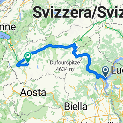
Von Verbania bis Locarno
A cycling route starting in Pallanza-Intra-Suna, Piedmont, Italy.
Overview
About this route
- 2 h 44 min
- Duration
- 42.3 km
- Distance
- 1,568 m
- Ascent
- 1,562 m
- Descent
- 15.4 km/h
- Avg. speed
- 353 m
- Max. altitude

Route quality
Waytypes & surfaces along the route
Waytypes
Quiet road
8 km
(19 %)
Access road
1.7 km
(4 %)
Surfaces
Paved
40.9 km
(97 %)
Unpaved
0.5 km
(1 %)
Asphalt
40.9 km
(97 %)
Ground
0.3 km
(<1 %)
Continue with Bikemap
Use, edit, or download this cycling route
You would like to ride Von Verbania bis Locarno or customize it for your own trip? Here is what you can do with this Bikemap route:
Free features
- Save this route as favorite or in collections
- Copy & plan your own version of this route
- Sync your route with Garmin or Wahoo
Premium features
Free trial for 3 days, or one-time payment. More about Bikemap Premium.
- Navigate this route on iOS & Android
- Export a GPX / KML file of this route
- Create your custom printout (try it for free)
- Download this route for offline navigation
Discover more Premium features.
Get Bikemap PremiumFrom our community
Other popular routes starting in Pallanza-Intra-Suna
 cicogna/alpe pala
- Distance
- 39.1 km
- Ascent
- 1,266 m
- Descent
- 534 m
- Location
- Pallanza-Intra-Suna, Piedmont, Italy
 verbania cannero
- Distance
- 18.9 km
- Ascent
- 386 m
- Descent
- 407 m
- Location
- Pallanza-Intra-Suna, Piedmont, Italy
 Tour of Suisse 2012 2nd Stage
- Distance
- 221 km
- Ascent
- 2,966 m
- Descent
- 1,677 m
- Location
- Pallanza-Intra-Suna, Piedmont, Italy
 aaaaa
aaaaa- Distance
- 109.8 km
- Ascent
- 1,010 m
- Descent
- 1,010 m
- Location
- Pallanza-Intra-Suna, Piedmont, Italy
 Von Verbania bis Locarno
- Distance
- 42.3 km
- Ascent
- 1,568 m
- Descent
- 1,562 m
- Location
- Pallanza-Intra-Suna, Piedmont, Italy
 mezzo lago
- Distance
- 92.9 km
- Ascent
- 297 m
- Descent
- 295 m
- Location
- Pallanza-Intra-Suna, Piedmont, Italy
 opdecahier_lagomaggiore2003_02
- Distance
- 107.3 km
- Ascent
- 2,173 m
- Descent
- 1,726 m
- Location
- Pallanza-Intra-Suna, Piedmont, Italy
 Verbania - Aurano - Piancavallo - Cannero - Verbania
- Distance
- 53.9 km
- Ascent
- 2,522 m
- Descent
- 2,499 m
- Location
- Pallanza-Intra-Suna, Piedmont, Italy
Open it in the app