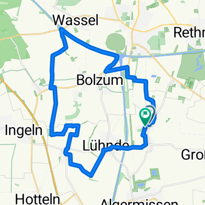
Reihwiesenweg, Algermissen nach Reihwiesenweg, Algermissen
A cycling route starting in Algermissen, Lower Saxony, Germany.
Overview
About this route
- 2 h 57 min
- Duration
- 57.1 km
- Distance
- 261 m
- Ascent
- 259 m
- Descent
- 19.4 km/h
- Avg. speed
- 139 m
- Avg. speed
Route quality
Waytypes & surfaces along the route
Waytypes
Path
30.5 km
(53 %)
Track
10.9 km
(19 %)
Surfaces
Paved
47.5 km
(83 %)
Unpaved
5.8 km
(10 %)
Asphalt
18.7 km
(33 %)
Concrete
13.5 km
(24 %)
Continue with Bikemap
Use, edit, or download this cycling route
You would like to ride Reihwiesenweg, Algermissen nach Reihwiesenweg, Algermissen or customize it for your own trip? Here is what you can do with this Bikemap route:
Free features
- Save this route as favorite or in collections
- Copy & plan your own version of this route
- Sync your route with Garmin or Wahoo
Premium features
Free trial for 3 days, or one-time payment. More about Bikemap Premium.
- Navigate this route on iOS & Android
- Export a GPX / KML file of this route
- Create your custom printout (try it for free)
- Download this route for offline navigation
Discover more Premium features.
Get Bikemap PremiumFrom our community
Other popular routes starting in Algermissen
- Algermissen-Hildesheim Panoramaweg
- Distance
- 42 km
- Ascent
- 305 m
- Descent
- 306 m
- Location
- Algermissen, Lower Saxony, Germany
- Leichte Feierabendrunde
- Distance
- 22.5 km
- Ascent
- 60 m
- Descent
- 64 m
- Location
- Algermissen, Lower Saxony, Germany
- Rundtour Region Hannover 20.-21.5.23
- Distance
- 288.3 km
- Ascent
- 1,487 m
- Descent
- 1,487 m
- Location
- Algermissen, Lower Saxony, Germany
- Lühnde Tour 90km
- Distance
- 89.1 km
- Ascent
- 509 m
- Descent
- 518 m
- Location
- Algermissen, Lower Saxony, Germany
- Reihwiesenweg, Algermissen nach Reihwiesenweg, Algermissen
- Distance
- 57.1 km
- Ascent
- 261 m
- Descent
- 259 m
- Location
- Algermissen, Lower Saxony, Germany
- Rundkurs ab Lühnde 65km
- Distance
- 64.2 km
- Ascent
- 288 m
- Descent
- 298 m
- Location
- Algermissen, Lower Saxony, Germany
- Trainigsroute 1
- Distance
- 21 km
- Ascent
- 53 m
- Descent
- 52 m
- Location
- Algermissen, Lower Saxony, Germany
- Ingeln - Anderter Bahnhof - Rundtour
- Distance
- 28.2 km
- Ascent
- 99 m
- Descent
- 101 m
- Location
- Algermissen, Lower Saxony, Germany
Open it in the app