

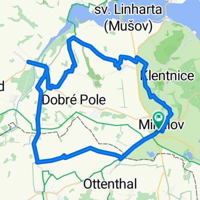
Route to Sedlec
A cycling route starting in Mikulov, South Moravian, Czechia.
Overview
About this route
- 2 h 29 min
- Duration
- 40.5 km
- Distance
- 319 m
- Ascent
- 319 m
- Descent
- 16.3 km/h
- Avg. speed
- 273 m
- Max. altitude
Route quality
Waytypes & surfaces along the route
Waytypes
Road
14.4 km
(36 %)
Track
8.9 km
(22 %)
Surfaces
Paved
25.7 km
(63 %)
Unpaved
0.7 km
(2 %)
Asphalt
25.7 km
(63 %)
Gravel
0.7 km
(2 %)
Continue with Bikemap
Use, edit, or download this cycling route
You would like to ride Route to Sedlec or customize it for your own trip? Here is what you can do with this Bikemap route:
Free features
- Save this route as favorite or in collections
- Copy & plan your own version of this route
- Sync your route with Garmin or Wahoo
Premium features
Free trial for 3 days, or one-time payment. More about Bikemap Premium.
- Navigate this route on iOS & Android
- Export a GPX / KML file of this route
- Create your custom printout (try it for free)
- Download this route for offline navigation
Discover more Premium features.
Get Bikemap PremiumFrom our community
Other popular routes starting in Mikulov
 Mikulov_Lednice_Mikulov_63_690
- Distance
- 63.1 km
- Ascent
- 831 m
- Descent
- 831 m
- Location
- Mikulov, South Moravian, Czechia
 Mikulov - Laa - Mikulov
- Distance
- 59.6 km
- Ascent
- 167 m
- Descent
- 127 m
- Location
- Mikulov, South Moravian, Czechia
 Route to Sedlec
- Distance
- 40.5 km
- Ascent
- 319 m
- Descent
- 319 m
- Location
- Mikulov, South Moravian, Czechia
 Náměstí 24/27, Mikulov do Náměstí 24/27, Mikulov
- Distance
- 25.3 km
- Ascent
- 374 m
- Descent
- 373 m
- Location
- Mikulov, South Moravian, Czechia
 Nova Cup - Mikulov A
- Distance
- 58.5 km
- Ascent
- 751 m
- Descent
- 738 m
- Location
- Mikulov, South Moravian, Czechia
 Okolo Mikulova 1
- Distance
- 30.7 km
- Ascent
- 359 m
- Descent
- 382 m
- Location
- Mikulov, South Moravian, Czechia
 Palavsky Krpal
- Distance
- 36.4 km
- Ascent
- 411 m
- Descent
- 394 m
- Location
- Mikulov, South Moravian, Czechia
 den 2 - Mikulov, Bavory, Dolni Dunajovice, Novosedly, Austria
- Distance
- 50.1 km
- Ascent
- 275 m
- Descent
- 284 m
- Location
- Mikulov, South Moravian, Czechia
Open it in the app