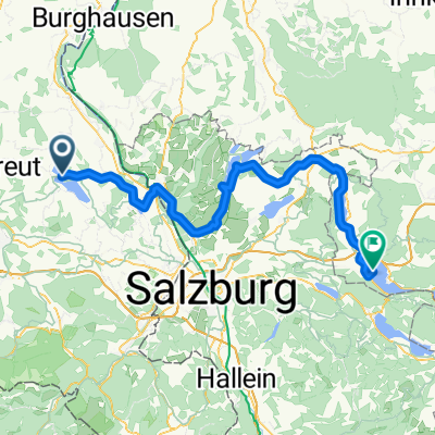
Sommerroute.Salzburger-Land.400 km
A cycling route starting in Taching am See, Bavaria, Germany.
Overview
About this route
- 24 h 30 min
- Duration
- 385 km
- Distance
- 5,970 m
- Ascent
- 5,975 m
- Descent
- 15.7 km/h
- Avg. speed
- 891 m
- Avg. speed
Route quality
Waytypes & surfaces along the route
Waytypes
Quiet road
159.9 km
(42 %)
Cycleway
57.7 km
(15 %)
Surfaces
Paved
252.7 km
(66 %)
Unpaved
46.5 km
(12 %)
Asphalt
246.2 km
(64 %)
Gravel
27.4 km
(7 %)
Continue with Bikemap
Use, edit, or download this cycling route
You would like to ride Sommerroute.Salzburger-Land.400 km or customize it for your own trip? Here is what you can do with this Bikemap route:
Free features
- Save this route as favorite or in collections
- Copy & plan your own version of this route
- Sync your route with Garmin or Wahoo
Premium features
Free trial for 3 days, or one-time payment. More about Bikemap Premium.
- Navigate this route on iOS & Android
- Export a GPX / KML file of this route
- Create your custom printout (try it for free)
- Download this route for offline navigation
Discover more Premium features.
Get Bikemap PremiumFrom our community
Other popular routes starting in Taching am See
- Sommerroute.Salzburger-Land.400 km
- Distance
- 384.4 km
- Ascent
- 6,001 m
- Descent
- 5,996 m
- Location
- Taching am See, Bavaria, Germany
- Buchberg-Tachinger-Waginger-Buchberg-bez nadstavby
- Distance
- 30.5 km
- Ascent
- 245 m
- Descent
- 245 m
- Location
- Taching am See, Bavaria, Germany
- Waginger See Über Mühlberg
- Distance
- 22.3 km
- Ascent
- 204 m
- Descent
- 204 m
- Location
- Taching am See, Bavaria, Germany
- Bucberg-Abtsdorfersee-Buchberg
- Distance
- 43.4 km
- Ascent
- 283 m
- Descent
- 287 m
- Location
- Taching am See, Bavaria, Germany
- Sommerroute.Salzburger-Land.400 km
- Distance
- 385 km
- Ascent
- 5,970 m
- Descent
- 5,975 m
- Location
- Taching am See, Bavaria, Germany
- Nördlicher Rupertigau
- Distance
- 38.1 km
- Ascent
- 291 m
- Descent
- 290 m
- Location
- Taching am See, Bavaria, Germany
- Lange Ausfahrt durch Taching am See
- Distance
- 44.5 km
- Ascent
- 246 m
- Descent
- 245 m
- Location
- Taching am See, Bavaria, Germany
- Rund um Waginger See
- Distance
- 35.4 km
- Ascent
- 305 m
- Descent
- 305 m
- Location
- Taching am See, Bavaria, Germany
Open it in the app