

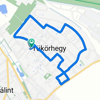
Szt István utca, Törökbálint - Szegfű utca, Diósd
A cycling route starting in Törökbálint, Pest County, Hungary.
Overview
About this route
- 30 min
- Duration
- 4.6 km
- Distance
- 103 m
- Ascent
- 79 m
- Descent
- 9.1 km/h
- Avg. speed
- 239 m
- Max. altitude

Route quality
Waytypes & surfaces along the route
Waytypes
Quiet road
1.9 km
(42 %)
Road
1.1 km
(23 %)
Surfaces
Paved
3 km
(66 %)
Unpaved
0.4 km
(9 %)
Asphalt
3 km
(66 %)
Unpaved (undefined)
0.4 km
(9 %)
Undefined
1.2 km
(25 %)
Continue with Bikemap
Use, edit, or download this cycling route
You would like to ride Szt István utca, Törökbálint - Szegfű utca, Diósd or customize it for your own trip? Here is what you can do with this Bikemap route:
Free features
- Save this route as favorite or in collections
- Copy & plan your own version of this route
- Sync your route with Garmin or Wahoo
Premium features
Free trial for 3 days, or one-time payment. More about Bikemap Premium.
- Navigate this route on iOS & Android
- Export a GPX / KML file of this route
- Create your custom printout (try it for free)
- Download this route for offline navigation
Discover more Premium features.
Get Bikemap PremiumFrom our community
Other popular routes starting in Törökbálint
 Fél-Lufiszív
- Distance
- 115.4 km
- Ascent
- 569 m
- Descent
- 599 m
- Location
- Törökbálint, Pest County, Hungary
 eMTB proba Bencevel
- Distance
- 4.3 km
- Ascent
- 46 m
- Descent
- 106 m
- Location
- Törökbálint, Pest County, Hungary
 Bajcsy-Zsilinszky utca - Tilos puszta
- Distance
- 95.3 km
- Ascent
- 612 m
- Descent
- 656 m
- Location
- Törökbálint, Pest County, Hungary
 Pannon út, Törökbálint to Szabadság híd, Budapest
- Distance
- 13.9 km
- Ascent
- 363 m
- Descent
- 416 m
- Location
- Törökbálint, Pest County, Hungary
 Törökbálint - Biatorbágy
- Distance
- 7 km
- Ascent
- 72 m
- Descent
- 68 m
- Location
- Törökbálint, Pest County, Hungary
 Tb Klein
- Distance
- 3.9 km
- Ascent
- 50 m
- Descent
- 50 m
- Location
- Törökbálint, Pest County, Hungary
 Szt István utca, Törökbálint - Szegfű utca, Diósd
- Distance
- 4.6 km
- Ascent
- 103 m
- Descent
- 79 m
- Location
- Törökbálint, Pest County, Hungary
 Törökbálint - Szentendre
- Distance
- 43.2 km
- Ascent
- 102 m
- Descent
- 167 m
- Location
- Törökbálint, Pest County, Hungary
Open it in the app