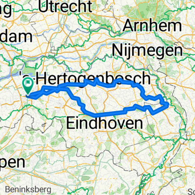
Brusselstraat, Breda do Brusselstraat, Breda
A cycling route starting in Hoge Vucht, North Brabant, The Netherlands.
Overview
About this route
- 1 h 33 min
- Duration
- 35.7 km
- Distance
- 61 m
- Ascent
- 61 m
- Descent
- 23.1 km/h
- Avg. speed
- 17 m
- Max. altitude
Route quality
Waytypes & surfaces along the route
Waytypes
Cycleway
18 km
(50 %)
Quiet road
12.6 km
(35 %)
Surfaces
Paved
18.6 km
(52 %)
Unpaved
2 km
(6 %)
Asphalt
10.4 km
(29 %)
Paving stones
6.8 km
(19 %)
Continue with Bikemap
Use, edit, or download this cycling route
You would like to ride Brusselstraat, Breda do Brusselstraat, Breda or customize it for your own trip? Here is what you can do with this Bikemap route:
Free features
- Save this route as favorite or in collections
- Copy & plan your own version of this route
- Sync your route with Garmin or Wahoo
Premium features
Free trial for 3 days, or one-time payment. More about Bikemap Premium.
- Navigate this route on iOS & Android
- Export a GPX / KML file of this route
- Create your custom printout (try it for free)
- Download this route for offline navigation
Discover more Premium features.
Get Bikemap PremiumFrom our community
Other popular routes starting in Hoge Vucht
- Brusselstraat, Breda do Brusselstraat, Breda
- Distance
- 35.7 km
- Ascent
- 61 m
- Descent
- 61 m
- Location
- Hoge Vucht, North Brabant, The Netherlands
- Rondje 7-bergen, Moerdijk, Dimmelen, Breda HB
- Distance
- 62.4 km
- Ascent
- 46 m
- Descent
- 46 m
- Location
- Hoge Vucht, North Brabant, The Netherlands
- Short round near Breda and Terheijden
- Distance
- 21 km
- Ascent
- 3 m
- Descent
- 6 m
- Location
- Hoge Vucht, North Brabant, The Netherlands
- Brusselstraat, Breda do Brusselstraat, Breda
- Distance
- 33.3 km
- Ascent
- 39 m
- Descent
- 42 m
- Location
- Hoge Vucht, North Brabant, The Netherlands
- Breda Drimmelen Breda
- Distance
- 53 km
- Ascent
- 25 m
- Descent
- 25 m
- Location
- Hoge Vucht, North Brabant, The Netherlands
- breda - deinze
- Distance
- 133.8 km
- Ascent
- 202 m
- Descent
- 197 m
- Location
- Hoge Vucht, North Brabant, The Netherlands
- Dorst-Oosterhout-Dongen-Rijen-Dorst 20k
- Distance
- 19.8 km
- Ascent
- 37 m
- Descent
- 35 m
- Location
- Hoge Vucht, North Brabant, The Netherlands
- Vijf Eiken rondje2
- Distance
- 17.7 km
- Ascent
- 38 m
- Descent
- 36 m
- Location
- Hoge Vucht, North Brabant, The Netherlands
Open it in the app