

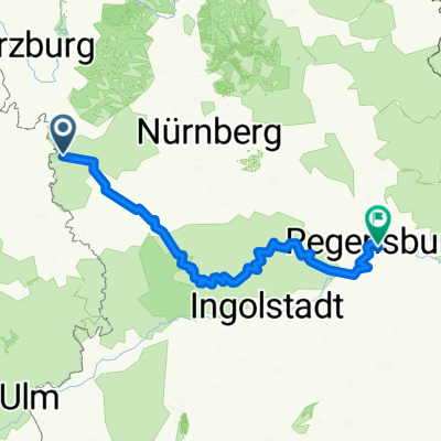
Rothenburg-Regensburg
A cycling route starting in Rothenburg upon Tauber, Bavaria, Germany.
Overview
About this route
Altmühl-Radweg (1)
Rothenburg an der Tauber nach Gunzenhaus
Köln Hbf (05:53) ICE 23 Intercity-Express Würzburg Hbf 09:31 Umsteigezeit 10 Min. Würzburg Hbf 09:41 RB 58111 Rothenburg ob der Tauber(Steinbach) (10:23)
- 16 h 32 min
- Duration
- 263.4 km
- Distance
- 1,292 m
- Ascent
- 1,373 m
- Descent
- 15.9 km/h
- Avg. speed
- 492 m
- Max. altitude

Route quality
Waytypes & surfaces along the route
Waytypes
Track
107.6 km
(41 %)
Quiet road
62.9 km
(24 %)
Surfaces
Paved
172.2 km
(65 %)
Unpaved
61.6 km
(23 %)
Asphalt
162.2 km
(62 %)
Gravel
39 km
(15 %)
Continue with Bikemap
Use, edit, or download this cycling route
You would like to ride Rothenburg-Regensburg or customize it for your own trip? Here is what you can do with this Bikemap route:
Free features
- Save this route as favorite or in collections
- Copy & plan your own version of this route
- Split it into stages to create a multi-day tour
- Sync your route with Garmin or Wahoo
Premium features
Free trial for 3 days, or one-time payment. More about Bikemap Premium.
- Navigate this route on iOS & Android
- Export a GPX / KML file of this route
- Create your custom printout (try it for free)
- Download this route for offline navigation
Discover more Premium features.
Get Bikemap PremiumFrom our community
Other popular routes starting in Rothenburg upon Tauber
 Rothenburg to Bamberg
- Distance
- 120.8 km
- Ascent
- 98 m
- Descent
- 285 m
- Location
- Rothenburg upon Tauber, Bavaria, Germany
 Altmühlradweg: Rothenburg-Kelheim
- Distance
- 244.8 km
- Ascent
- 316 m
- Descent
- 400 m
- Location
- Rothenburg upon Tauber, Bavaria, Germany
 Rothenburg-Tauberquelle
- Distance
- 44.7 km
- Ascent
- 278 m
- Descent
- 278 m
- Location
- Rothenburg upon Tauber, Bavaria, Germany
 Rothenburg Burgbernheim Runde
- Distance
- 30.5 km
- Ascent
- 266 m
- Descent
- 275 m
- Location
- Rothenburg upon Tauber, Bavaria, Germany
 Rund um Rothenburg
- Distance
- 23.1 km
- Ascent
- 463 m
- Descent
- 445 m
- Location
- Rothenburg upon Tauber, Bavaria, Germany
 35_Rothenburg ob der Tauber – Leutershausen
- Distance
- 41.9 km
- Ascent
- 171 m
- Descent
- 168 m
- Location
- Rothenburg upon Tauber, Bavaria, Germany
 Taubertal-Panorama
- Distance
- 52.4 km
- Ascent
- 733 m
- Descent
- 895 m
- Location
- Rothenburg upon Tauber, Bavaria, Germany
 Rothenburg-Regensburg
- Distance
- 263.4 km
- Ascent
- 1,292 m
- Descent
- 1,373 m
- Location
- Rothenburg upon Tauber, Bavaria, Germany
Open it in the app