
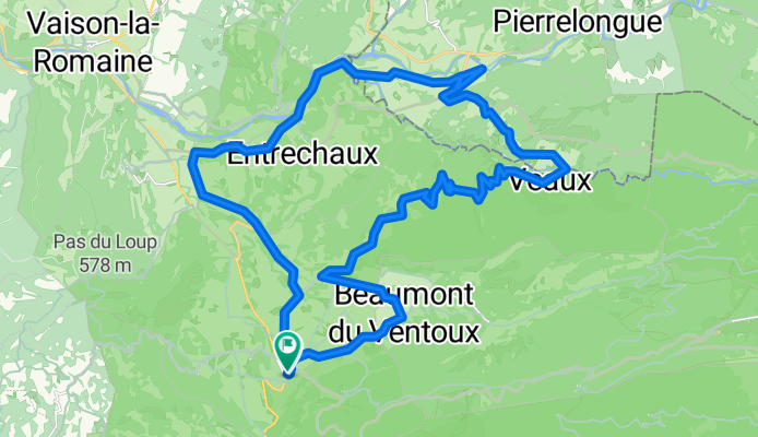
Malaucene III
A cycling route starting in Malaucène, Provence-Alpes-Côte d'Azur Region, France.
Overview
About this route
- -:--
- Duration
- 36.7 km
- Distance
- 430 m
- Ascent
- 430 m
- Descent
- ---
- Avg. speed
- ---
- Max. altitude

Route quality
Waytypes & surfaces along the route
Waytypes
Road
17.3 km
(47 %)
Quiet road
14.3 km
(39 %)
Surfaces
Paved
13.2 km
(36 %)
Asphalt
13.2 km
(36 %)
Undefined
23.5 km
(64 %)
Continue with Bikemap
Use, edit, or download this cycling route
You would like to ride Malaucene III or customize it for your own trip? Here is what you can do with this Bikemap route:
Free features
- Save this route as favorite or in collections
- Copy & plan your own version of this route
- Sync your route with Garmin or Wahoo
Premium features
Free trial for 3 days, or one-time payment. More about Bikemap Premium.
- Navigate this route on iOS & Android
- Export a GPX / KML file of this route
- Create your custom printout (try it for free)
- Download this route for offline navigation
Discover more Premium features.
Get Bikemap PremiumFrom our community
Other popular routes starting in Malaucène
 Malaucene Brantes
- Distance
- 57.9 km
- Ascent
- 1,005 m
- Descent
- 1,008 m
- Location
- Malaucène, Provence-Alpes-Côte d'Azur Region, France
 Rue du Capitaine Jallier, Malaucène nach Rue des Calignaires, Bédoin
- Distance
- 16.9 km
- Ascent
- 356 m
- Descent
- 380 m
- Location
- Malaucène, Provence-Alpes-Côte d'Azur Region, France
 MTB ein Versuch
- Distance
- 28 km
- Ascent
- 668 m
- Descent
- 660 m
- Location
- Malaucène, Provence-Alpes-Côte d'Azur Region, France
 Malaucène,Malaucène par le Mont Ventoux et Bedoin
- Distance
- 54.6 km
- Ascent
- 1,714 m
- Descent
- 1,714 m
- Location
- Malaucène, Provence-Alpes-Côte d'Azur Region, France
 petite boucle 2
- Distance
- 41.3 km
- Ascent
- 1,163 m
- Descent
- 1,163 m
- Location
- Malaucène, Provence-Alpes-Côte d'Azur Region, France
 Malaucene Vaison la Romaine
- Distance
- 10.5 km
- Ascent
- 33 m
- Descent
- 158 m
- Location
- Malaucène, Provence-Alpes-Côte d'Azur Region, France
 Baronnien und Touleranceschlucht
- Distance
- 121.4 km
- Ascent
- 1,454 m
- Descent
- 1,454 m
- Location
- Malaucène, Provence-Alpes-Côte d'Azur Region, France
 Mont Ventoux Südanstieg
- Distance
- 55.1 km
- Ascent
- 1,735 m
- Descent
- 1,732 m
- Location
- Malaucène, Provence-Alpes-Côte d'Azur Region, France
Open it in the app