

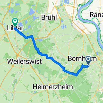
Römerkanal_Bonn_Köln_neu
A cycling route starting in Bornheim, North Rhine-Westphalia, Germany.
Overview
About this route
- 2 h 17 min
- Duration
- 33.7 km
- Distance
- 204 m
- Ascent
- 209 m
- Descent
- 14.8 km/h
- Avg. speed
- 137 m
- Max. altitude
Route quality
Waytypes & surfaces along the route
Waytypes
Path
13.8 km
(41 %)
Track
7.4 km
(22 %)
Surfaces
Paved
19.2 km
(57 %)
Unpaved
6.4 km
(19 %)
Asphalt
17.2 km
(51 %)
Unpaved (undefined)
3.4 km
(10 %)
Continue with Bikemap
Use, edit, or download this cycling route
You would like to ride Römerkanal_Bonn_Köln_neu or customize it for your own trip? Here is what you can do with this Bikemap route:
Free features
- Save this route as favorite or in collections
- Copy & plan your own version of this route
- Sync your route with Garmin or Wahoo
Premium features
Free trial for 3 days, or one-time payment. More about Bikemap Premium.
- Navigate this route on iOS & Android
- Export a GPX / KML file of this route
- Create your custom printout (try it for free)
- Download this route for offline navigation
Discover more Premium features.
Get Bikemap PremiumFrom our community
Other popular routes starting in Bornheim
 Von Bornheim bis Toto
- Distance
- 21.3 km
- Ascent
- 162 m
- Descent
- 126 m
- Location
- Bornheim, North Rhine-Westphalia, Germany
 Von Roisdorf durch den Kottenforst
- Distance
- 22 km
- Ascent
- 190 m
- Descent
- 113 m
- Location
- Bornheim, North Rhine-Westphalia, Germany
 Römerkanal_Bonn_Köln_neu
- Distance
- 33.7 km
- Ascent
- 204 m
- Descent
- 209 m
- Location
- Bornheim, North Rhine-Westphalia, Germany
 Bornheim - Bad Godesberg
- Distance
- 52.6 km
- Ascent
- 201 m
- Descent
- 201 m
- Location
- Bornheim, North Rhine-Westphalia, Germany
 Nedda🐴
- Distance
- 15.2 km
- Ascent
- 52 m
- Descent
- 36 m
- Location
- Bornheim, North Rhine-Westphalia, Germany
 Bonn Koln via Bruhl and Wesseling
- Distance
- 74.8 km
- Ascent
- 213 m
- Descent
- 206 m
- Location
- Bornheim, North Rhine-Westphalia, Germany
 Bornheim-Rheinbach-Kottenforst-Bonn-Bornheim
- Distance
- 58.4 km
- Ascent
- 281 m
- Descent
- 284 m
- Location
- Bornheim, North Rhine-Westphalia, Germany
 Schnelle Tour in Weilerswist coole strecke
- Distance
- 10.8 km
- Ascent
- 247 m
- Descent
- 227 m
- Location
- Bornheim, North Rhine-Westphalia, Germany
Open it in the app