

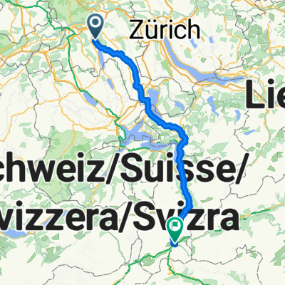
Wiederhergestellte Route
A cycling route starting in Egliswil, Canton of Aargau, Switzerland.
Overview
About this route
- 2 h 11 min
- Duration
- 46.2 km
- Distance
- 607 m
- Ascent
- 627 m
- Descent
- 21.2 km/h
- Avg. speed
- 569 m
- Max. altitude

Route quality
Waytypes & surfaces along the route
Waytypes
Quiet road
24.5 km
(53 %)
Track
10.2 km
(22 %)
Surfaces
Paved
17.1 km
(37 %)
Unpaved
3.2 km
(7 %)
Asphalt
10.6 km
(23 %)
Paved (undefined)
6.5 km
(14 %)
Continue with Bikemap
Use, edit, or download this cycling route
You would like to ride Wiederhergestellte Route or customize it for your own trip? Here is what you can do with this Bikemap route:
Free features
- Save this route as favorite or in collections
- Copy & plan your own version of this route
- Sync your route with Garmin or Wahoo
Premium features
Free trial for 3 days, or one-time payment. More about Bikemap Premium.
- Navigate this route on iOS & Android
- Export a GPX / KML file of this route
- Create your custom printout (try it for free)
- Download this route for offline navigation
Discover more Premium features.
Get Bikemap PremiumFrom our community
Other popular routes starting in Egliswil
 Mit der Apple Watch am 10. Mai, 16:18 aufgenommen
- Distance
- 37.1 km
- Ascent
- 733 m
- Descent
- 733 m
- Location
- Egliswil, Canton of Aargau, Switzerland
 Test
Test- Distance
- 6.7 km
- Ascent
- 36 m
- Descent
- 40 m
- Location
- Egliswil, Canton of Aargau, Switzerland
 Häbnistrasse 1–7, Egliswil nach Fluhbachstrasse 4, Uerkheim
- Distance
- 18.5 km
- Ascent
- 517 m
- Descent
- 518 m
- Location
- Egliswil, Canton of Aargau, Switzerland
 esterli 5weiher
- Distance
- 2.1 km
- Ascent
- 3 m
- Descent
- 128 m
- Location
- Egliswil, Canton of Aargau, Switzerland
 Häbnistrasse 1–7, Egliswil nach Dorfstrasse 22, Würenlos
- Distance
- 28.3 km
- Ascent
- 483 m
- Descent
- 531 m
- Location
- Egliswil, Canton of Aargau, Switzerland
 Wiederhergestellte Route
- Distance
- 46.2 km
- Ascent
- 607 m
- Descent
- 627 m
- Location
- Egliswil, Canton of Aargau, Switzerland
 Von Egliswil bis Andermatt
- Distance
- 123.5 km
- Ascent
- 3,567 m
- Descent
- 2,576 m
- Location
- Egliswil, Canton of Aargau, Switzerland
 Häbnistrasse 5, Egliswil nach Fluhbachstrasse 3, Uerkheim
- Distance
- 22.2 km
- Ascent
- 486 m
- Descent
- 487 m
- Location
- Egliswil, Canton of Aargau, Switzerland
Open it in the app