

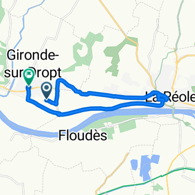
Day 3 La Camparaise - Bois de Cadenne
A cycling route starting in Gironde-sur-Dropt, Nouvelle-Aquitaine, France.
Overview
About this route
- 3 h 26 min
- Duration
- 62.3 km
- Distance
- 548 m
- Ascent
- 487 m
- Descent
- 18.1 km/h
- Avg. speed
- 90 m
- Max. altitude
Route quality
Waytypes & surfaces along the route
Waytypes
Cycleway
43.6 km
(70 %)
Road
10.6 km
(17 %)
Surfaces
Paved
51.7 km
(83 %)
Asphalt
31.2 km
(50 %)
Paved (undefined)
19.9 km
(32 %)
Continue with Bikemap
Use, edit, or download this cycling route
You would like to ride Day 3 La Camparaise - Bois de Cadenne or customize it for your own trip? Here is what you can do with this Bikemap route:
Free features
- Save this route as favorite or in collections
- Copy & plan your own version of this route
- Sync your route with Garmin or Wahoo
Premium features
Free trial for 3 days, or one-time payment. More about Bikemap Premium.
- Navigate this route on iOS & Android
- Export a GPX / KML file of this route
- Create your custom printout (try it for free)
- Download this route for offline navigation
Discover more Premium features.
Get Bikemap PremiumFrom our community
Other popular routes starting in Gironde-sur-Dropt
 short cut
- Distance
- 14.4 km
- Ascent
- 147 m
- Descent
- 87 m
- Location
- Gironde-sur-Dropt, Nouvelle-Aquitaine, France
 De 2 Fonfrede, Gironde-sur-Dropt à 5 Rue du Stade, Gironde-sur-Dropt
- Distance
- 10.2 km
- Ascent
- 132 m
- Descent
- 142 m
- Location
- Gironde-sur-Dropt, Nouvelle-Aquitaine, France
 5 day to Bordeaux
- Distance
- 73 km
- Ascent
- 263 m
- Descent
- 271 m
- Location
- Gironde-sur-Dropt, Nouvelle-Aquitaine, France
 les esseintes piste cyclable
- Distance
- 9.2 km
- Ascent
- 122 m
- Descent
- 91 m
- Location
- Gironde-sur-Dropt, Nouvelle-Aquitaine, France
 Dim P1 BC
- Distance
- 63.4 km
- Ascent
- 193 m
- Descent
- 174 m
- Location
- Gironde-sur-Dropt, Nouvelle-Aquitaine, France
 De 1 La Barrière, Les Esseintes à 13 Route d'Aillas, La Réole
- Distance
- 8.6 km
- Ascent
- 6 m
- Descent
- 16 m
- Location
- Gironde-sur-Dropt, Nouvelle-Aquitaine, France
 EuroVelo 3 - Part 16 - From La Réole to Sainte-Marie-de-Gosse
- Distance
- 272.3 km
- Ascent
- 335 m
- Descent
- 351 m
- Location
- Gironde-sur-Dropt, Nouvelle-Aquitaine, France
 Day 3 La Camparaise - Bois de Cadenne
- Distance
- 62.3 km
- Ascent
- 548 m
- Descent
- 487 m
- Location
- Gironde-sur-Dropt, Nouvelle-Aquitaine, France
Open it in the app