
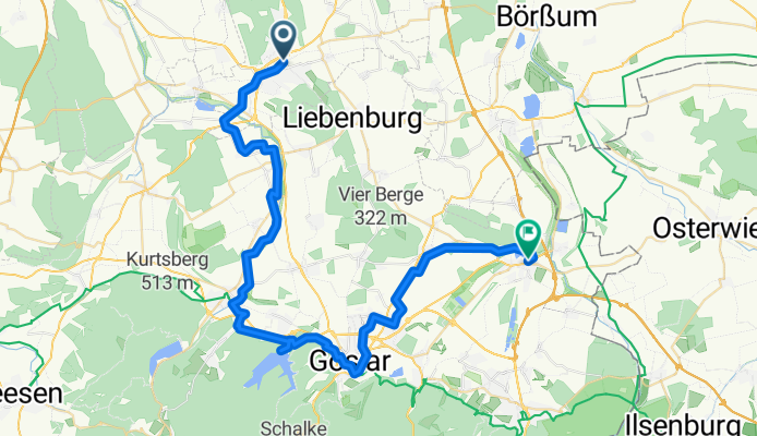
7. SZ Bad - Vienenburg
A cycling route starting in Liebenburg, Lower Saxony, Germany.
Overview
About this route
- 3 h 22 min
- Duration
- 48.3 km
- Distance
- 367 m
- Ascent
- 364 m
- Descent
- 14.4 km/h
- Avg. speed
- 313 m
- Max. altitude

Route quality
Waytypes & surfaces along the route
Waytypes
Track
17.4 km
(36 %)
Quiet road
10.6 km
(22 %)
Surfaces
Paved
21.2 km
(44 %)
Unpaved
15 km
(31 %)
Asphalt
20.7 km
(43 %)
Gravel
10.1 km
(21 %)
Continue with Bikemap
Use, edit, or download this cycling route
You would like to ride 7. SZ Bad - Vienenburg or customize it for your own trip? Here is what you can do with this Bikemap route:
Free features
- Save this route as favorite or in collections
- Copy & plan your own version of this route
- Sync your route with Garmin or Wahoo
Premium features
Free trial for 3 days, or one-time payment. More about Bikemap Premium.
- Navigate this route on iOS & Android
- Export a GPX / KML file of this route
- Create your custom printout (try it for free)
- Download this route for offline navigation
Discover more Premium features.
Get Bikemap PremiumFrom our community
Other popular routes starting in Liebenburg
 Lindenstraße nach Lindenstraße
- Distance
- 12.1 km
- Ascent
- 232 m
- Descent
- 278 m
- Location
- Liebenburg, Lower Saxony, Germany
 SZ-Sternplatz-Seesen-SZ
- Distance
- 58.8 km
- Ascent
- 475 m
- Descent
- 473 m
- Location
- Liebenburg, Lower Saxony, Germany
 D 008/2: Salzgitter-Bad - Gifhorn
- Distance
- 69 km
- Ascent
- 94 m
- Descent
- 171 m
- Location
- Liebenburg, Lower Saxony, Germany
 Liebenburg - Wolfenbüttel
- Distance
- 28.2 km
- Ascent
- 34 m
- Descent
- 96 m
- Location
- Liebenburg, Lower Saxony, Germany
 Klappe 6, Liebenburg nach Am Hamberg 94, Salzgitter
- Distance
- 10.5 km
- Ascent
- 94 m
- Descent
- 125 m
- Location
- Liebenburg, Lower Saxony, Germany
 Lewer Straße nach Lewer Straße
- Distance
- 40.3 km
- Ascent
- 232 m
- Descent
- 275 m
- Location
- Liebenburg, Lower Saxony, Germany
 Goslar Vorderland
- Distance
- 58.1 km
- Ascent
- 388 m
- Descent
- 388 m
- Location
- Liebenburg, Lower Saxony, Germany
 Rennradtour Ost, Tour I
- Distance
- 32.8 km
- Ascent
- 172 m
- Descent
- 172 m
- Location
- Liebenburg, Lower Saxony, Germany
Open it in the app