
Touren ab Stans
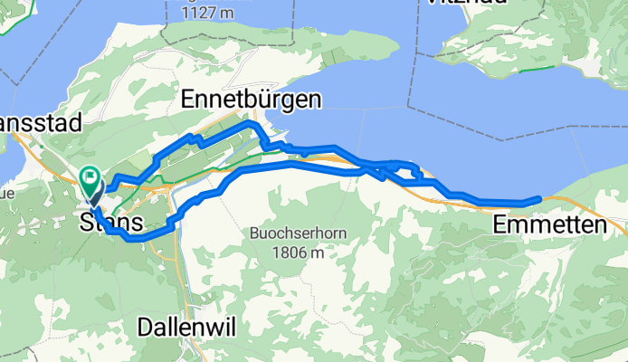
Rütenen über Ennerberg
A cycling route starting in Stans, Canton of Nidwalden, Switzerland.
Overview
About this route
- 1 h 54 min
- Duration
- 29.6 km
- Distance
- 418 m
- Ascent
- 421 m
- Descent
- 15.6 km/h
- Avg. speed
- 555 m
- Max. altitude

Part of
Touren ab Stans
6 stages
Route quality
Waytypes & surfaces along the route
Waytypes
Quiet road
17.2 km
(58 %)
Access road
3.9 km
(13 %)
Surfaces
Paved
14.5 km
(49 %)
Unpaved
1.2 km
(4 %)
Asphalt
14.5 km
(49 %)
Unpaved (undefined)
0.9 km
(3 %)
Continue with Bikemap
Use, edit, or download this cycling route
You would like to ride Rütenen über Ennerberg or customize it for your own trip? Here is what you can do with this Bikemap route:
Free features
- Save this route as favorite or in collections
- Copy & plan your own version of this route
- Sync your route with Garmin or Wahoo
Premium features
Free trial for 3 days, or one-time payment. More about Bikemap Premium.
- Navigate this route on iOS & Android
- Export a GPX / KML file of this route
- Create your custom printout (try it for free)
- Download this route for offline navigation
Discover more Premium features.
Get Bikemap PremiumFrom our community
Other popular routes starting in Stans
 Cervelo Teststrecke
- Distance
- 108.7 km
- Ascent
- 360 m
- Descent
- 359 m
- Location
- Stans, Canton of Nidwalden, Switzerland
 Stans-Büren-Broucs
- Distance
- 19 km
- Ascent
- 455 m
- Descent
- 458 m
- Location
- Stans, Canton of Nidwalden, Switzerland
 Stans, Alpgschwänd,Fräkmüntegg, Kriens, Stans
- Distance
- 41 km
- Ascent
- 2,465 m
- Descent
- 2,451 m
- Location
- Stans, Canton of Nidwalden, Switzerland
 St. Jakob über Rotzloch
- Distance
- 13.5 km
- Ascent
- 287 m
- Descent
- 285 m
- Location
- Stans, Canton of Nidwalden, Switzerland
 Bürgenstock über Fürigen
- Distance
- 23.3 km
- Ascent
- 608 m
- Descent
- 610 m
- Location
- Stans, Canton of Nidwalden, Switzerland
 Teil der Wettkampfstreck vom 12.9.10
- Distance
- 49.9 km
- Ascent
- 1,295 m
- Descent
- 1,295 m
- Location
- Stans, Canton of Nidwalden, Switzerland
 Stans-Oberdorf - Engelberg retour
- Distance
- 43.4 km
- Ascent
- 779 m
- Descent
- 778 m
- Location
- Stans, Canton of Nidwalden, Switzerland
 Rosenweg 9, Stans nach Stansstaderstrasse 39
- Distance
- 29.6 km
- Ascent
- 273 m
- Descent
- 267 m
- Location
- Stans, Canton of Nidwalden, Switzerland
Open it in the app