
warung Sanona
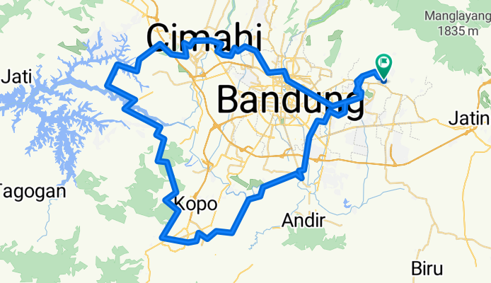
A cycling route starting in Bandung, West Java, Indonesia.
Overview
About this route
- 7 h 17 min
- Duration
- 107.4 km
- Distance
- 1,294 m
- Ascent
- 1,292 m
- Descent
- 14.7 km/h
- Avg. speed
- 878 m
- Avg. speed
Route quality
Waytypes & surfaces along the route
Waytypes
Quiet road
75.8 km
(71 %)
Road
20.4 km
(19 %)
Surfaces
Paved
16.6 km
(15 %)
Unpaved
0.1 km
(<1 %)
Asphalt
14.2 km
(13 %)
Concrete
1.8 km
(2 %)
Continue with Bikemap
Use, edit, or download this cycling route
You would like to ride warung Sanona or customize it for your own trip? Here is what you can do with this Bikemap route:
Free features
- Save this route as favorite or in collections
- Copy & plan your own version of this route
- Split it into stages to create a multi-day tour
- Sync your route with Garmin or Wahoo
Premium features
Free trial for 3 days, or one-time payment. More about Bikemap Premium.
- Navigate this route on iOS & Android
- Export a GPX / KML file of this route
- Create your custom printout (try it for free)
- Download this route for offline navigation
Discover more Premium features.
Get Bikemap PremiumFrom our community
Other popular routes starting in Bandung
 Cisanti Loop
- Distance
- 111.1 km
- Ascent
- 1,416 m
- Descent
- 1,417 m
- Location
- Bandung, West Java, Indonesia
 Puncak Bintang via Jatihandap
- Distance
- 8.9 km
- Ascent
- 702 m
- Descent
- 41 m
- Location
- Bandung, West Java, Indonesia
 Bike to care 2013 Sabtu, 9 Maret 2013
- Distance
- 18.9 km
- Ascent
- 125 m
- Descent
- 133 m
- Location
- Bandung, West Java, Indonesia
 Jumat ceria
- Distance
- 33.3 km
- Ascent
- 1,227 m
- Descent
- 636 m
- Location
- Bandung, West Java, Indonesia
 McD Dago - Warban - Warung Daweung
- Distance
- 28.3 km
- Ascent
- 794 m
- Descent
- 796 m
- Location
- Bandung, West Java, Indonesia
 Puncak Bintang via Caringin Tilu
- Distance
- 2.5 km
- Ascent
- 270 m
- Descent
- 54 m
- Location
- Bandung, West Java, Indonesia
 Tamiya (Start Point) via Cimuncang
- Distance
- 5 km
- Ascent
- 303 m
- Descent
- 10 m
- Location
- Bandung, West Java, Indonesia
 Route to Gunung Bukittunggul
- Distance
- 28.1 km
- Ascent
- 1,866 m
- Descent
- 422 m
- Location
- Bandung, West Java, Indonesia
Open it in the app