

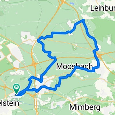
Unterasbach -Schweinauer Bug - TSV Katzwang V1
A cycling route starting in Wendelstein, Bavaria, Germany.
Overview
About this route
- 2 h 31 min
- Duration
- 38.9 km
- Distance
- 296 m
- Ascent
- 292 m
- Descent
- 15.5 km/h
- Avg. speed
- 377 m
- Max. altitude

Route quality
Waytypes & surfaces along the route
Waytypes
Quiet road
0 km
(<1 %)
Undefined
38.9 km
(100 %)
Continue with Bikemap
Use, edit, or download this cycling route
You would like to ride Unterasbach -Schweinauer Bug - TSV Katzwang V1 or customize it for your own trip? Here is what you can do with this Bikemap route:
Free features
- Save this route as favorite or in collections
- Copy & plan your own version of this route
- Sync your route with Garmin or Wahoo
Premium features
Free trial for 3 days, or one-time payment. More about Bikemap Premium.
- Navigate this route on iOS & Android
- Export a GPX / KML file of this route
- Create your custom printout (try it for free)
- Download this route for offline navigation
Discover more Premium features.
Get Bikemap PremiumFrom our community
Other popular routes starting in Wendelstein
 Schwaig - Ungelstetten1
- Distance
- 41.4 km
- Ascent
- 380 m
- Descent
- 378 m
- Location
- Wendelstein, Bavaria, Germany
 Testroute mittellang
- Distance
- 13.1 km
- Ascent
- 71 m
- Descent
- 68 m
- Location
- Wendelstein, Bavaria, Germany
 Altmühl Alles
- Distance
- 369.6 km
- Ascent
- 3,199 m
- Descent
- 3,196 m
- Location
- Wendelstein, Bavaria, Germany
 Altmühl 1
- Distance
- 203.2 km
- Ascent
- 1,465 m
- Descent
- 1,440 m
- Location
- Wendelstein, Bavaria, Germany
 Schwaig Tiergarten
- Distance
- 39.8 km
- Ascent
- 268 m
- Descent
- 273 m
- Location
- Wendelstein, Bavaria, Germany
 Lockere Sonntagsaufahrt
- Distance
- 44.8 km
- Ascent
- 248 m
- Descent
- 247 m
- Location
- Wendelstein, Bavaria, Germany
 RRS059Pyrbaum-Seligenporten-Ebenried-Rothsee-Schwand
- Distance
- 54.4 km
- Ascent
- 352 m
- Descent
- 348 m
- Location
- Wendelstein, Bavaria, Germany
 Brunn - Netzstall- Ungelstetten -Runde V 2
- Distance
- 36.9 km
- Ascent
- 376 m
- Descent
- 376 m
- Location
- Wendelstein, Bavaria, Germany
Open it in the app