

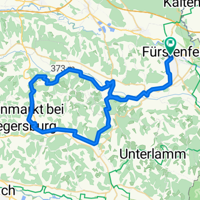
4. Tag, 20.05.25: Fürstenfeld nach Bad Radkersburg
A cycling route starting in Fürstenfeld, Styria, Austria.
Overview
About this route
- 3 h 31 min
- Duration
- 58.5 km
- Distance
- 787 m
- Ascent
- 848 m
- Descent
- 16.6 km/h
- Avg. speed
- 402 m
- Max. altitude

Route quality
Waytypes & surfaces along the route
Waytypes
Quiet road
39.8 km
(68 %)
Track
4.7 km
(8 %)
Surfaces
Paved
53.2 km
(91 %)
Unpaved
4.7 km
(8 %)
Asphalt
51.5 km
(88 %)
Gravel
4.7 km
(8 %)
Continue with Bikemap
Use, edit, or download this cycling route
You would like to ride 4. Tag, 20.05.25: Fürstenfeld nach Bad Radkersburg or customize it for your own trip? Here is what you can do with this Bikemap route:
Free features
- Save this route as favorite or in collections
- Copy & plan your own version of this route
- Sync your route with Garmin or Wahoo
Premium features
Free trial for 3 days, or one-time payment. More about Bikemap Premium.
- Navigate this route on iOS & Android
- Export a GPX / KML file of this route
- Create your custom printout (try it for free)
- Download this route for offline navigation
Discover more Premium features.
Get Bikemap PremiumFrom our community
Other popular routes starting in Fürstenfeld
 Hauptstraße 2a nach Hauptstraße 2a
- Distance
- 43.9 km
- Ascent
- 465 m
- Descent
- 462 m
- Location
- Fürstenfeld, Styria, Austria
 Fürstenfeld nach Bad Radkersburg
- Distance
- 60.3 km
- Ascent
- 797 m
- Descent
- 855 m
- Location
- Fürstenfeld, Styria, Austria
 Oststeirisches Hügelland (+Backhendl)
- Distance
- 21.5 km
- Ascent
- 349 m
- Descent
- 348 m
- Location
- Fürstenfeld, Styria, Austria
 4. Tag, 20.05.25: Fürstenfeld nach Bad Radkersburg
- Distance
- 58.5 km
- Ascent
- 787 m
- Descent
- 848 m
- Location
- Fürstenfeld, Styria, Austria
 Fürstenfeld - SCS
- Distance
- 151.7 km
- Ascent
- 1,136 m
- Descent
- 1,167 m
- Location
- Fürstenfeld, Styria, Austria
 Fürstenfeld - Aspang
- Distance
- 88.5 km
- Ascent
- 982 m
- Descent
- 737 m
- Location
- Fürstenfeld, Styria, Austria
 Kalcher Runde
- Distance
- 68.5 km
- Ascent
- 441 m
- Descent
- 441 m
- Location
- Fürstenfeld, Styria, Austria
 4 Elemente Tour WASSER 1 im Thermen- & Vulkanland Steiermark
- Distance
- 277.6 km
- Ascent
- 1,552 m
- Descent
- 1,554 m
- Location
- Fürstenfeld, Styria, Austria
Open it in the app