

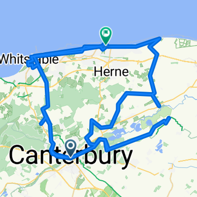
From Canterbury to Ashford
A cycling route starting in Canterbury, England, United Kingdom.
Overview
About this route
- 1 h 5 min
- Duration
- 17.4 km
- Distance
- 139 m
- Ascent
- 116 m
- Descent
- 15.9 km/h
- Avg. speed
- 68 m
- Max. altitude

Route quality
Waytypes & surfaces along the route
Waytypes
Cycleway
5.9 km
(34 %)
Road
4.7 km
(27 %)
Surfaces
Paved
10.2 km
(59 %)
Unpaved
5.6 km
(32 %)
Asphalt
10.1 km
(58 %)
Gravel
5.6 km
(32 %)
Continue with Bikemap
Use, edit, or download this cycling route
You would like to ride From Canterbury to Ashford or customize it for your own trip? Here is what you can do with this Bikemap route:
Free features
- Save this route as favorite or in collections
- Copy & plan your own version of this route
- Sync your route with Garmin or Wahoo
Premium features
Free trial for 3 days, or one-time payment. More about Bikemap Premium.
- Navigate this route on iOS & Android
- Export a GPX / KML file of this route
- Create your custom printout (try it for free)
- Download this route for offline navigation
Discover more Premium features.
Get Bikemap PremiumFrom our community
Other popular routes starting in Canterbury
 Sunday ride
- Distance
- 98 km
- Ascent
- 547 m
- Descent
- 547 m
- Location
- Canterbury, England, United Kingdom
 Recovered Route
- Distance
- 6.8 km
- Ascent
- 287 m
- Descent
- 286 m
- Location
- Canterbury, England, United Kingdom
 I tappa Canterbury - Dover
- Distance
- 31.5 km
- Ascent
- 300 m
- Descent
- 303 m
- Location
- Canterbury, England, United Kingdom
 From Canterbury to grand St Bernard pass
- Distance
- 1,159.1 km
- Ascent
- 11,967 m
- Descent
- 9,512 m
- Location
- Canterbury, England, United Kingdom
 Coastal route
- Distance
- 92.7 km
- Ascent
- 288 m
- Descent
- 298 m
- Location
- Canterbury, England, United Kingdom
 Day 2 Kent
- Distance
- 63.3 km
- Ascent
- 380 m
- Descent
- 380 m
- Location
- Canterbury, England, United Kingdom
 FH Wye Stelling Minnis
- Distance
- 47.8 km
- Ascent
- 290 m
- Descent
- 293 m
- Location
- Canterbury, England, United Kingdom
 Crab and Winkle
- Distance
- 94.7 km
- Ascent
- 619 m
- Descent
- 627 m
- Location
- Canterbury, England, United Kingdom
Open it in the app