

valle los ajos-carcedo
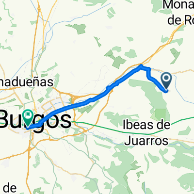
A cycling route starting in Atapuerca, Castille and León, Spain.
Overview
About this route
- -:--
- Duration
- 102 km
- Distance
- 846 m
- Ascent
- 825 m
- Descent
- ---
- Avg. speed
- ---
- Max. altitude
Continue with Bikemap
Use, edit, or download this cycling route
You would like to ride valle los ajos-carcedo or customize it for your own trip? Here is what you can do with this Bikemap route:
Free features
- Save this route as favorite or in collections
- Copy & plan your own version of this route
- Split it into stages to create a multi-day tour
- Sync your route with Garmin or Wahoo
Premium features
Free trial for 3 days, or one-time payment. More about Bikemap Premium.
- Navigate this route on iOS & Android
- Export a GPX / KML file of this route
- Create your custom printout (try it for free)
- Download this route for offline navigation
Discover more Premium features.
Get Bikemap PremiumFrom our community
Other popular routes starting in Atapuerca
 valle los ajos-carcedo
- Distance
- 102 km
- Ascent
- 846 m
- Descent
- 825 m
- Location
- Atapuerca, Castille and León, Spain
 Itinéraire confortable en Atapuerca
- Distance
- 21.5 km
- Ascent
- 149 m
- Descent
- 239 m
- Location
- Atapuerca, Castille and León, Spain
 étape 6
- Distance
- 20.8 km
- Ascent
- 88 m
- Descent
- 189 m
- Location
- Atapuerca, Castille and León, Spain
 11ages_burgos_sole
- Distance
- 22.9 km
- Ascent
- 155 m
- Descent
- 262 m
- Location
- Atapuerca, Castille and León, Spain
 burgos / Atapuerca
- Distance
- 20.3 km
- Ascent
- 74 m
- Descent
- 152 m
- Location
- Atapuerca, Castille and León, Spain
 Camino : Atapuerca - Burgos
- Distance
- 19.3 km
- Ascent
- 38 m
- Descent
- 128 m
- Location
- Atapuerca, Castille and León, Spain
 Burgos
- Distance
- 24.9 km
- Ascent
- 123 m
- Descent
- 228 m
- Location
- Atapuerca, Castille and León, Spain
 2011 Santiago: 4. dan (Ages - Boadilla del Camino)
- Distance
- 92 km
- Ascent
- 358 m
- Descent
- 542 m
- Location
- Atapuerca, Castille and León, Spain
Open it in the app