

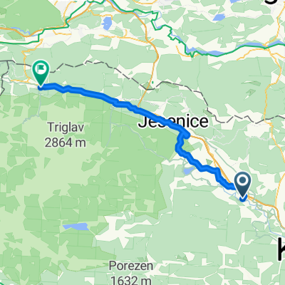
Day 6 | Radovljica to Kranjska Gora
A cycling route starting in Radovljica, Radovljica, Slovenia.
Overview
About this route
Starting point: your hotel Time planning: full day Food and Water: plenty of opportunities along the way On a rainy day: 1. Public Transport: you can use the train from station Radovljica to Jesenice. 2. Taxi: We will be happy to arrange a taxi for you. Extra charges will be applied accordingly. This route will take you along the edge of the Kamnik-Savinja Alps to the historic village of Begunje. It was in this small settlement where one of Slovenia’s darkest moments took place. Visit the Museum of Hostages and learn how thousands of men, women and children were beaten and executed during the German occupation in WW2. On a lighter note, Begunje is also the hometown of the famous Slavko Avsenik / Oberkrainer band. 2 km down the road are the ruins of Kamen Castle. As the sun illuminates the mountains your route will take you on a cycling path that goes between the ranges of the Julian Alps and the Karawanke Mountains to Kranjska Gora, a popular alpine town famous for its ski resorts, but also a great base for many summer activities. If you arrive in plenty of time you can take a ride up to the Planica Valley, the location for the world-famous ski jumping championships. It’s here that many of the longest jumps have been achieved, including the current world record.
- 3 h 30 min
- Duration
- 49.4 km
- Distance
- 871 m
- Ascent
- 551 m
- Descent
- 14.1 km/h
- Avg. speed
- 812 m
- Max. altitude
Continue with Bikemap
Use, edit, or download this cycling route
You would like to ride Day 6 | Radovljica to Kranjska Gora or customize it for your own trip? Here is what you can do with this Bikemap route:
Free features
- Save this route as favorite or in collections
- Copy & plan your own version of this route
- Sync your route with Garmin or Wahoo
Premium features
Free trial for 3 days, or one-time payment. More about Bikemap Premium.
- Navigate this route on iOS & Android
- Export a GPX / KML file of this route
- Create your custom printout (try it for free)
- Download this route for offline navigation
Discover more Premium features.
Get Bikemap PremiumFrom our community
Other popular routes starting in Radovljica
 Entlang der Sava nach Bled
- Distance
- 33.8 km
- Ascent
- 556 m
- Descent
- 557 m
- Location
- Radovljica, Radovljica, Slovenia
 bike tour from 2. maj 17:16
- Distance
- 24.6 km
- Ascent
- 548 m
- Descent
- 548 m
- Location
- Radovljica, Radovljica, Slovenia
 Day 6 | Radovljica to Kranjska Gora
- Distance
- 49.4 km
- Ascent
- 871 m
- Descent
- 551 m
- Location
- Radovljica, Radovljica, Slovenia
 2016 bike tour opening
- Distance
- 20.5 km
- Ascent
- 575 m
- Descent
- 575 m
- Location
- Radovljica, Radovljica, Slovenia
 Vodiška planina/Kropa
- Distance
- 26.6 km
- Ascent
- 788 m
- Descent
- 792 m
- Location
- Radovljica, Radovljica, Slovenia
 Jesenice - Sv. Duh
- Distance
- 47.6 km
- Ascent
- 494 m
- Descent
- 602 m
- Location
- Radovljica, Radovljica, Slovenia
 Eco River camp (Radovljica)-Natura Eco camp (Kranjska Gora) 50 km
- Distance
- 49.5 km
- Ascent
- 1,047 m
- Descent
- 650 m
- Location
- Radovljica, Radovljica, Slovenia
 Radovljica – Bled – Radovna – Mojstrana – Slovenski Javornik – Žirovnica – Spodnji Otok – Radovljica
- Distance
- 66.5 km
- Ascent
- 1,135 m
- Descent
- 1,135 m
- Location
- Radovljica, Radovljica, Slovenia
Open it in the app