
Von Baum zu Baum - Tour 5
A cycling route starting in Neubeuern, Bavaria, Germany.
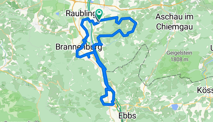
Overview
About this route
A tour of approximately 62 km with 400 meters of elevation gain up the Samerberg. / The Mühltal is temporarily closed due to flood damage, so please use road RO9. / ! Please watch out for traffic !
- -:--
- Duration
- 71.2 km
- Distance
- 860 m
- Ascent
- 860 m
- Descent
- ---
- Avg. speed
- 788 m
- Max. altitude
Continue with Bikemap
Use, edit, or download this cycling route
You would like to ride Von Baum zu Baum - Tour 5 or customize it for your own trip? Here is what you can do with this Bikemap route:
Free features
- Save this route as favorite or in collections
- Copy & plan your own version of this route
- Sync your route with Garmin or Wahoo
Premium features
Free trial for 3 days, or one-time payment. More about Bikemap Premium.
- Navigate this route on iOS & Android
- Export a GPX / KML file of this route
- Create your custom printout (try it for free)
- Download this route for offline navigation
Discover more Premium features.
Get Bikemap PremiumFrom our community
Other popular routes starting in Neubeuern
 Große Winklrunde
- Distance
- 14.5 km
- Ascent
- 141 m
- Descent
- 141 m
- Location
- Neubeuern, Bavaria, Germany
 Schlierseerunde
- Distance
- 75.3 km
- Ascent
- 600 m
- Descent
- 600 m
- Location
- Neubeuern, Bavaria, Germany
 Sachrang Runde über Niederndorf
- Distance
- 60.8 km
- Ascent
- 474 m
- Descent
- 474 m
- Location
- Neubeuern, Bavaria, Germany
 Jobtrail (shortV1)
- Distance
- 5.1 km
- Ascent
- 31 m
- Descent
- 23 m
- Location
- Neubeuern, Bavaria, Germany
 Mutterberg (1262m)
- Distance
- 45.4 km
- Ascent
- 983 m
- Descent
- 982 m
- Location
- Neubeuern, Bavaria, Germany
 Sachrangrunde andersrum
- Distance
- 60.2 km
- Ascent
- 387 m
- Descent
- 373 m
- Location
- Neubeuern, Bavaria, Germany
 Siemseerunde
- Distance
- 49.6 km
- Ascent
- 375 m
- Descent
- 375 m
- Location
- Neubeuern, Bavaria, Germany
 Dandlberg
- Distance
- 33.4 km
- Ascent
- 1,082 m
- Descent
- 1,119 m
- Location
- Neubeuern, Bavaria, Germany
Open it in the app