
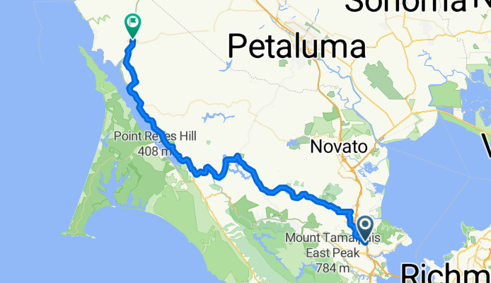
Bike Rte 5, San Rafael to CA-1, Tomales
A cycling route starting in San Rafael, California, United States.
Overview
About this route
- 3 h 53 min
- Duration
- 66.1 km
- Distance
- 1,301 m
- Ascent
- 1,306 m
- Descent
- 17 km/h
- Avg. speed
- 213 m
- Max. altitude
Route quality
Waytypes & surfaces along the route
Waytypes
Road
29.8 km
(45 %)
Quiet road
7.3 km
(11 %)
Surfaces
Paved
39.7 km
(60 %)
Unpaved
4 km
(6 %)
Asphalt
39 km
(59 %)
Unpaved (undefined)
4 km
(6 %)
Continue with Bikemap
Use, edit, or download this cycling route
You would like to ride Bike Rte 5, San Rafael to CA-1, Tomales or customize it for your own trip? Here is what you can do with this Bikemap route:
Free features
- Save this route as favorite or in collections
- Copy & plan your own version of this route
- Sync your route with Garmin or Wahoo
Premium features
Free trial for 3 days, or one-time payment. More about Bikemap Premium.
- Navigate this route on iOS & Android
- Export a GPX / KML file of this route
- Create your custom printout (try it for free)
- Download this route for offline navigation
Discover more Premium features.
Get Bikemap PremiumFrom our community
Other popular routes starting in San Rafael
 12 Greenfield Ave, San Rafael to 12 Greenfield Ave, San Rafael
- Distance
- 24.6 km
- Ascent
- 296 m
- Descent
- 297 m
- Location
- San Rafael, California, United States
 San Rafael Cycling
- Distance
- 26.2 km
- Ascent
- 268 m
- Descent
- 236 m
- Location
- San Rafael, California, United States
 Baytrail project North North
- Distance
- 137.3 km
- Ascent
- 217 m
- Descent
- 221 m
- Location
- San Rafael, California, United States
 335 Irwin St, San Rafael to 2–12 Corte Del Coronado, Larkspur
- Distance
- 14.2 km
- Ascent
- 0 m
- Descent
- 3 m
- Location
- San Rafael, California, United States
 china camp loop
- Distance
- 21.2 km
- Ascent
- 264 m
- Descent
- 267 m
- Location
- San Rafael, California, United States
 SR - ALPINE LAKE - SHORELINE - LAGUNITAS - SR
- Distance
- 58.4 km
- Ascent
- 1,098 m
- Descent
- 1,097 m
- Location
- San Rafael, California, United States
 San Rafael - Olema - Bolina - Alpine Dam - San Anselmo
- Distance
- 76.4 km
- Ascent
- 981 m
- Descent
- 978 m
- Location
- San Rafael, California, United States
 Circum-NorthBay
- Distance
- 185 km
- Ascent
- 928 m
- Descent
- 915 m
- Location
- San Rafael, California, United States
Open it in the app