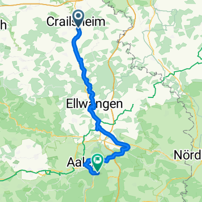
1997 Jagst ab Crailsheim
A cycling route starting in Crailsheim, Baden-Wurttemberg, Germany.
Overview
About this route
very beautiful river, little traffic, nice villages... one of the most beautiful up to the Neckar at Jagstfeld
2 days
- -:--
- Duration
- 123.6 km
- Distance
- 1,497 m
- Ascent
- 1,719 m
- Descent
- ---
- Avg. speed
- 440 m
- Max. altitude
Route quality
Waytypes & surfaces along the route
Waytypes
Track
50.7 km
(41 %)
Quiet road
17.3 km
(14 %)
Surfaces
Paved
90.2 km
(73 %)
Unpaved
11.1 km
(9 %)
Asphalt
76.6 km
(62 %)
Paved (undefined)
12.4 km
(10 %)
Route highlights
Points of interest along the route
Point of interest after 54.3 km
Ü Platz,Wasser
Point of interest after 80.2 km
sehenswertes kloster,cafe,Wasser,badestelle in der jagst
Point of interest after 102.8 km
Wasser
Point of interest after 121.4 km
Hängemattenplatz
Continue with Bikemap
Use, edit, or download this cycling route
You would like to ride 1997 Jagst ab Crailsheim or customize it for your own trip? Here is what you can do with this Bikemap route:
Free features
- Save this route as favorite or in collections
- Copy & plan your own version of this route
- Split it into stages to create a multi-day tour
- Sync your route with Garmin or Wahoo
Premium features
Free trial for 3 days, or one-time payment. More about Bikemap Premium.
- Navigate this route on iOS & Android
- Export a GPX / KML file of this route
- Create your custom printout (try it for free)
- Download this route for offline navigation
Discover more Premium features.
Get Bikemap PremiumFrom our community
Other popular routes starting in Crailsheim
- Crailsheim - Wörnitz - Crailsheim
- Distance
- 62.6 km
- Ascent
- 375 m
- Descent
- 374 m
- Location
- Crailsheim, Baden-Wurttemberg, Germany
- Oberspeltach-Jagstheim-Jagstzell-Rosenberg und wieder zurück
- Distance
- 37.9 km
- Ascent
- 263 m
- Descent
- 264 m
- Location
- Crailsheim, Baden-Wurttemberg, Germany
- 1997 Jagst ab Crailsheim
- Distance
- 123.6 km
- Ascent
- 1,497 m
- Descent
- 1,719 m
- Location
- Crailsheim, Baden-Wurttemberg, Germany
- Onolzheim-Kirchberg-Insingen-Schnelldorf-Onolzheim
- Distance
- 73.1 km
- Ascent
- 427 m
- Descent
- 408 m
- Location
- Crailsheim, Baden-Wurttemberg, Germany
- Oberspeltach-Ilshofen und zurück
- Distance
- 34.2 km
- Ascent
- 174 m
- Descent
- 175 m
- Location
- Crailsheim, Baden-Wurttemberg, Germany
- Onolzheim-Westliche Dörfer-Onolzheim
- Distance
- 64.4 km
- Ascent
- 474 m
- Descent
- 474 m
- Location
- Crailsheim, Baden-Wurttemberg, Germany
- Abendtour
- Distance
- 26.9 km
- Ascent
- 156 m
- Descent
- 157 m
- Location
- Crailsheim, Baden-Wurttemberg, Germany
- Gründscher Brunnen, Frankenhardt nach Haller Straße 10, Crailsheim
- Distance
- 14.1 km
- Ascent
- 106 m
- Descent
- 111 m
- Location
- Crailsheim, Baden-Wurttemberg, Germany
Open it in the app